|
Joseph Maser |
Nehalem
River Watershed Assessment |
Chapters
Contents1.0 Introduction
2.0 Historical Conditions
3.0 Channel Habitat Types
4.0 Hydrology and Water Use
5.0 Riparian Conditions
6.0 Sediment Sources
7.0 Channel Modifications
8.0 Water Quality
9.0 Fish and Fish Habitat
10.0 Watershed Conditions Summary
Home
Projects
PSU
ESR Dept.
Historical information can provide important clues concerning the status of the watershed in its natural condition. Information was gathered from a variety of sources including agency documents, interviews, literature and museums. Particular attention was given to issues that relate to landscape conditions, stream habitat, fish populations and water quality. This information can be used to identify changes, both human and natural, which may have impacted salmonid populations.
Methodology
Existing information was gathered by interviewing long-time residents, and from literature sources and museums. Information was organized into a historical narrative and time line which tells the “story” of the Nehalem River watershed in terms of possible impacts to water quality, fish habitat, and changes in fish abundance.
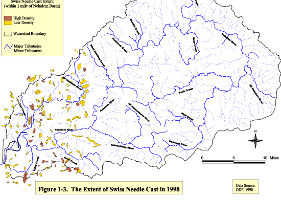
| Figure 1-3 Click image to see full size image. Use you back button to return to this page. |
|
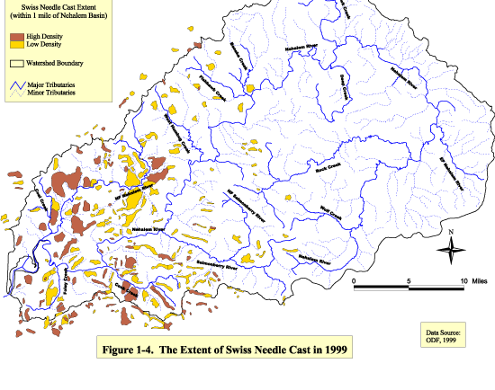
| Figure 1-4 Click image to see full size image. Use you back button to return to this page. |
Time Line
The historical conditions timeline provides a chronological list of natural and human-caused events that have helped shape the watershed.
~ 12,000 BC Catastrophic floods shaped much of the region and deposited thick soil
pre-history Nehalem Indians inhabited area around Nehalem Bay
1770 - 1780s European settlers came to Oregon Coast for exploration and trading
1782 - 83 Epidemics wiped out 75 to 90% of the Indian population
~ 1800 Fire 2 ½ miles south of Mist - burned thousands of acres
1841 Missionary, Reverend John Frost came to Clatsop region to christianize the Indians
1850 Donation Land Law, large pieces of Oregon Territory land were donated to settlers
1862 Federal Homestead Act, 160 acre parcels could be purchased for a small fee
1866 Hans Anderson was the first settler in the Nehalem Valley
1868 Pioneers settled the towns of Nehalem and Wheeler
1870 Earliest mail route in Tillamook County
1873 Pioneers were coming to Nehalem Valley to settle and clear land for farming
1874 Jewell established
1877-78 Pittsburg lumber mill built, powered by a 20 ft. dam across the East Fork of the Nehalem River
1894 Flood Event
1901-1926 Log drives occurred on the Nehalem River
1902-1930 Wheeler sawmill in operation
1909 Port of Nehalem was formed
1911 Railroad connecting Portland with Tillamook County completed
1911/1912 The town of Timber thriving, small sawmill and railroad tracks built
1916 Jetty at mouth of Nehalem River completed
1920s Logging Activity Exploded
Dike wall constructed to direct river flow (and logs) towards the Wheeler sawmill
1922 Railroad to Vernonia built
1926 Hatchery operations at Foley Creek began
1930 Bridge in Vernonia built for $12,000
1933 (Aug.) “Tillamook Burn”
1933 (Dec.) Flood Event
1935 Commercial fishing on the Nehalem River
1941 Highway 101 completed along coast
1945 “Salmonberry Fire” damaged Cook Creek and Salmonberry River drainages
1945 Old growth timber gone
1949 Rehabilitation began on the Tillamook Burn area
1955 Flood Event
1956 Commercial gill net fishing ended in estuary
1957 Vernonia sawmill closed
1966 Nehalem Hatchery began operations on the North Fork Nehalem
1973 Tillamook Burn Rehabilitation completed
1990 Flood Event
1996 Major Flood Event
1996 Upper Nehalem Watershed Council formed
1997 Lower Nehalem Watershed Council formed
Historical Narrative
Early Inhabitant History
The Nehalem River is named for the Indians who lived in the watershed for thousands of years before the area was discovered by European settlers. They lived in small villages clustered along the coastal rivers. The Nehalems visited and intermarried with the Clatsop Indians to the north and the Tillamook Indians to the south (Cotton, 1997).
There were two major natural resources used by Indians in the area: salmon in the rivers and seafood along the shoreline. In addition, the Coast Range provided game and berries and served as a partial barrier between coastal and inland tribes. In order to keep grass growing on mountainsides for deer and elk, Indians regularly burned trees and brush every few years (NVHS). The predictable timing of salmon migrations for spawning provided Indians with a dependable means of catching fish and rich symbolism regarding the renewal of life. The Indians only took enough fish for their own use or for trading dried fish with other tribes (Zucker et al, 1983). Historically, runs of Chinook, Coho, and Steelhead trout must have been tremendous as evidenced by catch records starting in 1923 (ODFW, 1993).
Exploration/Settlement History
In the 1770 and 1780s, European explorers and traders made their first contact with region’s Indians. The Indians were exposed to diseases to which they had no resistance and died in large numbers. Epidemics occurred along the Oregon Coast in 1782 - 83 (Zucker et al., 1983). Estimates of the loss of life range from 75 to 90 percent. Disease took a further toll on the Indian population in the region when well-meaning missionaries arrived in 1841. The last full-blooded Indian from the area, Ella Center, died in 1959 at 97 years old (TPA, 1972).
Hans Anderson was the first pioneer to settle in the Nehalem Valley in 1866. He resided near Elsie close to River Mile 40. His main means of travel was canoe. Many more pioneers settled the upper and lower watershed during the following decade. The trees were so abundant that in order to build a cabin or clear land for farming, the pioneers had to cut any trees in their way as they moved westward. This process was called “cut, burn, and move on syndrome” (NVHS). Thousands of trees were cut and either burned or left to decay. Pioneers generally followed narrow Indian trails from the Willamette and Columbia River Basins to the Nehalem Valley. Gravel was eventually removed from the bed of the Nehalem River to construct roads along these routes (Blackburn, 1995).
Settlement and Management Trends
Soon after the settlers arrived, a sawmill was built at Wheeler. Farmers from dairy farms made their way to town by wagon or boat and built two cheese factories. Logging and farming were booming by the end of the 19th century (NVHS). And by 1906, the Neahkanie mountain area was used extensively for sheep and cattle grazing.
A survey done by Reverend K. Hines in 1893 described vast forests in the region averaging 250 feet in height and four to six feet in diameter, with trees frequently 350 feet in height and 10 feet in diameter. Species included Douglas fir, cedar, spruce, oak, maple and alder (Bourhill, 1994). The ages of stumps of redwood trees and Port Orford cedar trees in the Nehalem Bay area have been recorded as 1700 years old (NVHS).
Logging began early and gained momentum as the area became more populated. Early settlers took advantage of the relatively smooth flowing river as a highway in which to transport lumber (Cotton, 1997). In addition to the Wheeler sawmill, mills were eventually built at Pittsburg and Vernonia. Log drives down the Nehalem River started in 1901 and lasted until 1926.
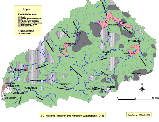
Log drives were done extensively. Logs were floated down rivers on high winter flows. This practice scoured the river bottom and swept large woody debris structure downstream. The riparian vegetation along stream banks was also damaged as logs were dragged into the river. Figure 2-1 shows old growth timber lying on the bank of the Nehalem River in 1907. A splash dam existed on the North Fork Nehalem. The river was dammed so that water and logs were backed up behind the dam. Then the dam was released along with the cascading water and logs to go to the sawmill downstream. The dike wall at Wheeler was constructed in the early 1920s to direct the water and logs to the Wheeler sawmill. It is estimated that a hundred million board feet of timber were floated out of the North Fork of the Nehalem River, mostly with the assistance of splash dams (Farnell, 1981). Figure 2-2 shows the amount of land with merchantable timber still available in 1914. The last old growth timber in the watershed was cut in 1945 (Sword, 1999).
Several major fires are on record as occurring in the watershed. The first occurred around 1800, 2 ½ miles south of Mist. Thousands of acres burned. In August, 1933, the famous “Tillamook Burn” burned 270,000 acres. A spark generated by a lone logger near Gales Creek ignited the dry forest. High temperatures, extreme low humidity, and strong winds from the east pushed the fire westward (Fick & Martin, 1992). The Salmonberry River, Cook, Humbug, and Rock Creek drainages were extensively damaged as well as the mainstem of the Nehalem River from River Mile 12 to 42 (Weber & Knispel, 1972). The Salmonberry River and Cook Creek drainages were burned again in the “Salmonberry Fire” of 1945. High temperatures, ash fall, and subsequent siltation undoubtedly had serious consequences for aquatic life.
The Tillamook burn destroyed much of the timber value of these lands and many of the landowners in the area could not pay their taxes, resulting in foreclosure and transfer of ownership to the counties. Most of these lands were then transferred to the State Board of Forestry to be managed to maximize long-term values to Oregonians. One of the determined values was timber production (Fick & Martin, 1992). This value, in combination with an effort to minimize future fire risk, spurred a reforestation program which began in 1949. Nearly 76 million Douglas Fir seedlings were planted over 96,753 acres of the original Tillamook Burn area and 118,065 acres were seeded by helicopter (Fick & Martin, 1992). Rehabilitation was completed in 1973. The trees that were planted during this period are nearing first harvest size.
Fish were historically abundant in the region. One early visitor to the Nehalem River remembers salmon actually jumping into her parents boat around the year 1918 (NVHS). Fishing remained excellent between 1920 and 1940 despite the severely damaged watershed. One angler stated that he and a partner took 23 steelhead in 4 hours at River Mile 8 in 1938. Angling was good in the 1940’s but declined in the 1950’s. Some improvement was noted after commercial gill net fishing ended in 1956 (Weber & Knispel, 1977).
Commercial fishing contributed substantially to the general economy. Nearly everyone that lived in the valley got into the fishing business at least part-time. Although, fisherman did not make much money, some people spent all their lives taking fish. They worked whenever the fish were running. They moved in and out of the area depending on quantities of fish available . Gill nets were extensively used to catch mature fish swimming upstream. Gill nets allow the smaller, immature fish to get through the net. In order to prevent spoilage of the commercial harvests, fish canneries were built in Wheeler and canned fish was shipped mainly by rail. During the off-season, fisherman would clear large woody debris from the river which hung up and tore their nets. As the fish populations declined, the State of Oregon finally stopped all commercial fishing on the rivers of Oregon with the exception of the Columbia River. Limited sport fishing is still allowed (NVHS).
In order to sustain fisheries, a hatchery on Foley Creek began operations in 1926 to supplement wild populations of cutthroat trout and winter steelhead trout. The hatchery was closed in 1966 and replaced by the North Nehalem Hatchery. This hatchery raises coho and chinook, along with winter steelhead trout. Hatchery runs have had limited success as they are less resistant than wild populations to disease which is exacerbated by high stream temperatures in the lower mainstem (Weber & Knispel, 1977).
Conclusion
Historic forest harvest and commercial fishing practices have changed the landscape and stream characteristics in the Nehalem River watershed. The extent of damage caused by specific activities on fish and fish habitat is impossible to determine, however the cumulative effect of these activities gives an indication of the reasons for decline in salmonid populations since European settlement. With this information, we can begin to identify potential restoration opportunities.
| Figure
2-1 Click image to see full size image. Use you back button to return to this page. |
|
| Figure 2-2 Click image to see full size image. Use you back button to return to this page. |
Data Gaps
1. Historical maps showing land use practices such as logging, farming, county planning, agriculture and flood control were not located for this assessment.
2. Historical landscape photographs were not located.
3. US Army Corps of Engineers snag removal records should be obtained.
4. General Land Office survey records were not obtained.
5. Tax records were not analyzed.
References
-
Blackburn, E. 1995. Nehalem Valley: Bits ‘O History, 88 pp.
-
Bourhill, B. 1994. History of Oregon’s Timber Harvests and/or Lumber Production, Oregon Department of Forestry.
-
Cotton, S.J. 1997. Stories of Nehalem, Maverick Publications, Bend, OR, 147 pp.
-
Farnell, J.E. 1981. Nehalem, Necanicum, Nestucca Navagability Studies, Division of State Lands, Salem, Oregon, 38 pp
-
Fick, L. and Martin, G. 1992. The Tillamook Burn: Rehabilitation and Restoration, Oregon Department of Forestry, Forest Grove, OR, 320 pp.
-
Fulton, A. 1997. Vernonia: A Pocket in the Woods, 115 pp.
-
Memorial Society of the Nehalem Bay United Methodist Church (NBUMC). 1970. 100 Years of the Nehalem Country, Pacific Yearbook Co., Nehalem, OR, 163 pp.
-
Nehalem Valley Historical Society (NVHS). No date given. A Patchwork History of Nehalem Bay, 181 pp.
-
Oregon Department of Fish and Wildlife. 1993. Draft: Nehalem Basin Plan.
-
Shuford, D. (Manager, Tillamook Resource Area). 1996. East Fork Nehalem Watershed Analysis, Bureau of Land Management, Tillamook, OR, 85 pp.
-
Sword, B. (curator). 1999. Personal Communication. Columbia County Historical Museum, Vernonia, Oregon.
-
Tillamook Pioneer Association (TPA). 1972. Tillamook Memories, 218 pp.
-
United States Geographical Survey (USGS). 1998. Peak Flow Data .
-
Weber, W. and Knispel, W. 1977. Final Report: Anadromous Fish Conservation Project, US Fish and Wildlife Service, Portland, OR, 101 pp.
-
Zucker, J., Hummel, K., and Hogfoss, B. 1983. Oregon Indians: Culture, History & Current Affairs, Press of the Oregon Historical Society, USA, 229 pp.
| Maintained by Joseph
Maser |