|
Joseph Maser |
Nehalem
River Watershed Assessment |
Chapters
Contents1.0 Introduction
2.0 Historical Conditions
3.0 Channel Habitat Types
4.0 Hydrology and Water Use
5.0 Riparian Conditions
6.0 Sediment Sources
7.0 Channel Modifications
8.0 Water Quality
9.0 Fish and Fish Habitat
10.0 Watershed Conditions Summary
Home
Projects
PSU
ESR Dept.
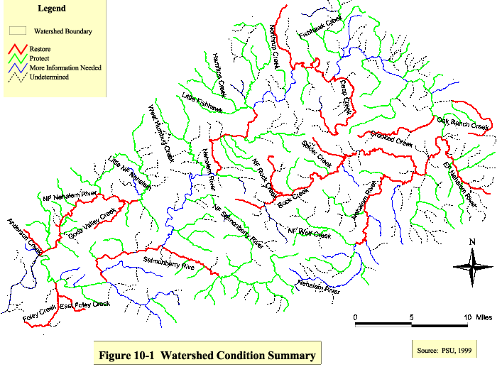
This section gives a brief summary of the results of each assessment component. Data gaps are identified, including information which will require further assessment and monitoring. Additionally, recommendations for potential restoration activities are discussed.
Summary information for specific streams is provided in Table 10-1. Most streams longer than one mile were included. The results from each assessment component were used to determine whether the findings warranted protection, restoration or more information. The total number of ratings in each category were totaled and an overall evaluation was made for each stream (or stream segment). According to GWEB (1999) protocol, streams with relatively high-quality stream/riparian habitat, fish populations, or water quality conditions were categorized as “Protect”. Streams with low-quality stream/riparian habitat, limitations on fish presence or production, or water quality concerns were categorized as “Restore”. The streams where stream/riparian condition, fish populations, or water quality cannot be accurately determined and/or the links to the impacts are not clear were grouped into “More Information Needed”.
Information for restoration activities that have already been completed is not yet available and will be provided in the final draft of this manual.
The Nehalem Basin Plan is not yet completed by ODFW. The final document will be useful to the Nehalem River Watershed Councils in prioritizing and planning restoration efforts.
Historical Conditions
Summary
Prior to European settlement, vast old-growth Douglas fir forests dominated the Nehalem Watershed. Logging operations started in the 1870's until the last old-growth trees were harvested in 1945. Log drives were done extensively throughout the watershed and a splash dam operated on the North Fork Nehalem. These practices scoured river beds and damaged riverbanks. The Salmonberry River, Cook, Humbug, and Rock Creek drainages were extensively burned by the "Tillamook Burn" in 1933. The "Salmonberry Fire" burned the Salmonberry River and Cook Creek drainages again in 1945. There was an intensive re-planting effort which lasted until 1973. There are numerous accounts of abundant fish populations in
harvest and cannery records in the watershed through the 1940's. Commercial gill netting was stopped in 1956.
Data Gaps
1. Historical maps showing land use practices such as logging, farming, county planning, agriculture and flood control were not located for this assessment.
2. Historical landscape photographs were not located.
3. US Army Corps of Engineers snag removal records should be obtained.
4. General Land Office survey records were not obtained.
5. Tax records were not analyzed.
Recommendations
A more extensive investigation could be made of historical conditions and their impacts on streams. An understanding of activities which altered fish habitat can help council members focus restoration efforts.
Channel Habitat Types
Summary
Channel reaches were characterized to determine where the highest potential for fish utilization and restoration opportunities exist. Channel habitat type classifications were based on stream gradient, channel confinement and stream size. The channel habitat types were further classified into channel habitat type sensitivity ratings that predict which reaches are likely to respond well to restoration activities. About 50% of the reaches in the watershed were classified as highly sensitive to changes. The reaches in the Salmonberry subwatershed, however, were only 19% highly sensitive and 45% of the reaches were expected to have a low level of response to channel changes. The highly sensitive reaches were generally unconfined or moderately confined. This included much of the mainstem Nehalem River and its major tributaries.
Data Gaps
1. Field surveys of the quantity and quality of flood plain and wetland habitat are needed.
2. A 1:24,000 scale stream map was not available in GIS at the time of this assessment.
Recommendations
When a restoration project is being considered, field verification of channel habitat type should be done due to periodic changes in stream channel characteristics due to altered hydrology. Also, the channel habitat types are general groupings, they may not be accurate descriptions of isolated segments.
At the time of this assessment, a GIS stream coverage in 1:24,000 scale was not available. Channel confinement should be re-analyzed when a 1:24,000 scale stream theme is available.
The channel habitat type sensitivity ratings should be used to determine where restoration efforts would likely be successful. This information combined with findings in other sections of the assessment will help identify where restoration efforts will be successful.
Hydrology and Water Use
Summary
Rainfall in the Nehalem Watershed ranges from 55 inches near Vernonia to 200 inches in the higher elevations of the Salmonberry subwatershed. Average annual snowfall is 2.8 inches in Nehalem and 11.4 inches in Vernonia. Snow accumulation generally is quickly washed away by winter rains. Major floods were recorded in the watershed in 1933, 1955, 1990 and 1996. The flooding in February 1996 was caused by an unusual rain-on-snow event where snow accumulated even in the lowest elevations of the watershed and was followed by warm rain. The storm produced the record peak streamflow of 70,300 cubic feet per second.
The impact of landuses on hydrology were small on a subwatershed scale. Ninety-two percent of the land use in the Nehalem Watershed is forestry. According to GWEB recommendations, the major hydrologic impact from harvested land is related to rain-on-snow events. These events are very infrequent in the Nehalem Watershed. The densities of forestry related roads were found to be less than 2% in all subwatersheds, and therefore had minimal potential impact to hydrology. Potential impacts from agricultural and urban areas were generally low due to the small area of these landuses (1.7% agriculture, 0.5% urban) in the watershed.
There are 542 permitted water rights in the Nehalem Watershed. Estimates were made for potential low flows. Potential water deficits are possible throughout the watershed in the summer months. There is no large-scale means of supplementing summer low flows. ODFW and the OWRD have prioritized water availability basins for restoration of streamflow. High priority reaches include most of the mainstem Nehalem River during the summer months.
Data Gaps
1. Information on the degree of actual water use is needed.
2. The extent of illegal water diversions should be researched.
3. Snow accumulation data in the highest elevations is not available.
4. Information regarding the specific crop rotations in the Nehalem Watershed is needed, including water needs and estimated return flows.
5. Information is needed regarding livestock operations, including animal populations and management practices.
Recommendations
Maintaining stream flows for fish use should be a high priority. Purchasing and leasing senior water rights and dedicating them to instream use is a common strategy. Incentives should be given to water rights holders who conserve water. The watershed councils can help promote conservation practices and support the leasing or buying of water rights for instream use.
The possibility of water storage facilities for municipalities could be explored. Peak demand for water occurs at the same time as summer low flows.
Riparian Conditions
Summary
Riparian buffers are generally in good condition. There are isolated reaches and small tributaries with poor conditions scattered throughout the watershed. These streams typically have no vegetation or only grass on their banks. The Upper Nehalem subwatershed had the most marginally adequate riparian area. About 50% of the riparian zones in this subwatershed were less than 30 feet wide.
Current levels of large woody debris are low. The potential for future recruitment of large woody debris was analyzed. There is generally less potential for recruitable wood in the upper watershed, however 76% of the watershed has good potential for recruitment of large woody debris. Large sized wood material provides better habitat than small woody debris. Reaches surveyed by ODFW had 52% of their riparian trees less than 20 inches in diameter.
Data Gaps
1. Information for all reaches was not available regarding presence of large woody debris and tree species.
2. GIS information for wetlands in the Nehalem Watershed is not available.
3. Agricultural and rangeland practices need to be investigated for use or non-use of buffer strips.
4. Presence and distribution of non-native riparian vegetation should be determined.
5. Correlations should be made between stream shade provided and stream temperatures.
Recommendations
Improving riparian areas for shading and large woody debris recruitment should be a high priority for the watershed councils. The council can work with willing landowners to investigate and implement riparian vegetation plantings. The highest priority areas are on the small tributaries in the northeast part of the watershed (Eastman, Cedar, Battle, Gus, and North Fork Fishhawk Creek). These areas should be investigated in terms of feasibility of riparian vegetation plantings. Also, native vegetation riparian plantings can be encouraged in the urban areas.
Sediment Sources
Summary
The potential sources of sediment for the Nehalem Watershed were determined to be rural road instability, slope instability and erosion from road. Rural road instability data was not available from private landowners. Some culvert data was available through the Oregon Department of Transportation. This information was oriented toward fish passage, not sediment delivery to streams. Road crossings were calculated by subwatershed. The highest densities of road crossings were in the North Fork Nehalem subwatershed.
Slope instability was determined using ODF classifications. Twenty-five percent of the Cook Creek subwatershed and 20% of the Salmonberry subwatershed was determined to have significant landslide hazard (>60% slope). The rest of the subwatersheds have less than 5% of their areas in the high risk category.
Roads within 200 feet of streams are the most likely to have ditches which flow directly into streams. Twenty-nine percent of the road length in the watershed (1:100,000 scale) is within 200 feet of streams. Roads within 200 feet of streams and with steep side slopes (>50%) occurred increase the likelihood of erosional processes which may affect streams. A total of 2.72 miles in the Cook Creek subwatershed were in this category and .89 and .62 miles in the Salmonberry and Lower Nehalem subwatersheds, respectively. No roads within 200 feet of streams were on steep slopes (>50%) in the remaining subwatersheds.
Data Gaps
1. Complete road inventory data is needed including slumps, cracks, and water running down roads or onto an unstable fill.
2. Road surface information is needed including the extent to which the roads are used.
3. An inventory of road instability data should be kept including road construction, landslide locations, landslide type, whether or not it reached a stream, what distance it traveled, and road position.
4. ODF culvert information was not yet available.
5. ODF landslide hazard maps were not yet available.
6. Drainage areas and peak flow amounts above culverts need to be calculated to determine whether culverts are appropriately sized.
Recommendations
Field surveys of the roads on steep slopes should be conducted, especially in the Cook and Salmonberry subwatersheds to evaluate the condition of roads and the potential for sediment delivery to streams. The Oregon Department of Forestry will be done with a GIS landslide hazard map early in the year 2000.
The Oregon Department of Forestry is also nearing completion on a GIS culvert layer. This should be obtained as soon as possible and analyzed for potential restoration projects.
Channel Modifications
Summary
Historic and current alterations to stream channels were identified to the extent that information was available. Interviews were done with long-time residents and retired Oregon Department of Wildlife and Oregon Department of Forestry scientists to identify historic channel modifications. Logging activities which started in the late 1800’s resulted in many channel disturbances including small-scale diversions, dredging, dikes, and dams. Probably the most extensive type of modifications were log drives. A splash dam operated on the North Fork Nehalem River.
Current channel modifications are much less common than those that occurred historically with large-scale logging operations. There were 150 permitted channel modifications listed with Division of State Lands. Thirty-nine percent of the permits were for erosion/flood control and 18% were for road and bridge construction. Probably the most damaging recent channel modifications are associated with instream gravel mining (permitted and illegal). It is unknown how many culverts in the watershed represent passage barriers for fish.
Data Gaps
1. A complete inventory of culverts was not available.
2. Channel modification information was not available from private landowners.
3. Channel modification information in GIS was lacking. A more extensive search for records could be done and digitized if location descriptions of modifications are adequate.
Recommendations
Barriers to fish passage should be high priority. Inadequate culverts limit the amount of good habitat available and increases competition among salmonids. Known problems need to be corrected as soon as feasible. Appropriate culvert construction should be researched and a coordinated plan could be developed for building and maintaining culverts. The North Fork Nehalem subwatershed should be given high priority for culvert restorations due to high fish use, especially for chum salmon which are poor leapers. This information could be shared with landowners.
The upper and mainstem Nehalem River should be protected from instream gravel mining, where most of the summer chinook spawning occurs. Inquires should be made to the Division of State Lands regarding current policy on issuing gravel removal permits. Education of landowners could be done to stress the importance of not disturbing stream beds.
Water Quality
Summary
The mainstem Nehalem River, from the mouth to Rock Creek, is listed by the Department of Environmental Quality as water quality limited due to elevated water temperatures in the summer season. Nehalem Bay is also water quality limited due to elevated bacteria levels. Temperature data collected by the Nehalem River Watershed Councils showed that 27 of the 48 collection sites sampled exceeded DEQ’s temperature standard of 64°F more than 30 times during the summer of 1998. During winter months, nitrate levels become elevated in the mainstem as a result of winter rainfall washing organic materials from land surfaces. No impairments were found for dissolved oxygen, pH, phosphorus, bacteria, and turbidity.
Data Gaps
1. There is no comprehensive water quality monitoring program in the watershed. Very little water quality data is available for such a large watershed. There is only one DEQ monitoring site which is sampled six times yearly.
2. Watershed council data for parameters besides temperature were not yet available (will be included in the final manual).
Recommendations
Water quality data should continue to be collected by the Nehalem River watershed councils. The data should be analyzed for trends and exceedances of DEQ standards. Specific water quality standards for the Nehalem Watershed are being established by DEQ and should be completed in 2001. A well-distributed program is necessary in order to pinpoint possible causes of water quality standards not being met.
Levels of pesticides in streams should also be studied.
Fish and Fish Habitat
Summary
The Nehalem Watershed has runs of summer and fall chinook salmon, chum salmon, winter steelhead, coho salmon, and sea-run cutthroat trout. The only species which appears stable or increasing in population is winter steelhead. One of Oregon’s healthiest winter steelhead runs exists in the Salmonberry River. Coho salmon are listed as threatened on the endangered species list. While wild coho populations in the NehalemWatershed are depressed, they have a high conservation significance due to the worse status of coho populations in the basins to the north and south of the Nehalem Basin. Hatchery influence on coho has been heavy. Summer chinook populations are very small and are limited by good spawning habitat. There are healthy fall chinook populations in the large tributaries of the lower basin, but numbers have gradually declined since 1985. Sea-run cutthroat trout have been proposed for threatened status under the Endangered Species Act. Data is lacking for cutthroat trout, but a widespread decline is evident.
Oregon Department of Fish and Wildlife surveys conducted between 1993 and 1997 were used to evaluate habitat distribution and quality. While the frequency of pools was adequate, the size and complexity of the pools was inadequate. The quantity of key pieces of large woody debris (>0.6 m in diameter and 10 m long) that would substantially improve habitat conditions was small. While 43% of the reaches surveyed had desirable quantities of large woody debris, the volume of large woody debris was desirable in only 19% of reaches surveyed. Gravel quantities were generally borderline adequate. Riparian vegetation was primarily comprised of hardwoods which were providing adequate shade (primarily small and medium size tributaries were surveyed), but little large woody debris recruitment opportunity to streams.
Data Gaps
1. More information is needed regarding historic salmonid population abundance and historic distributions.
2. Extensive field surveys of fish barriers are needed.
3. Habitat surveys are needed for all un-surveyed stream reaches and updated surveys are needed on a continual basis.
4. Reliable and regular fish counts are needed to track trends in fish populations (spawning adults, juveniles, hatchery releases and returns).
5. Macroinvertebrate data collected by the Nehalem watershed councils was not yet available (probably will be included in final draft of this manual).
Recommendations
Restoration activities should be oriented toward improving the quantity and quality of salmonid habitat. The lack of key pieces of large woody debris warrants placement of logs or root wads in streams. Field visits should be done prior to placement to verify conditions in isolated reaches. Also, conifer species should be used when riparian area restoration projects are conducted, as they provide future potential for large woody debris recruitment. As ODFW conducts further surveys, the data should be analyzed using the ODFW benchmarks (included in the Appendix) to determine where additional undesirable habitat conditions exist. New benchmarks may be established if sea-run cutthroat trout are added to the endangered species list.
When comprehensive fish passage barrier information is available, the potential restoration needs identified should be prioritized according to the extent and quality of habitat available above the barrier. The same judgment needs to be taken regarding rip-rap and other alterations which interfere with natural stream processes and fish habitat. Large woody debris could be placed instream to replace the rip-rap, which would provide some stability to the bank as well as fish habitat, however, the amount of fish habitat being obstructed needs to be weighed against other potential restoration projects and the availability of resources (money, people, time).
| Fig
10.1 Click image to see full size image. Use you back button to return to this page. |
| Maintained by Joseph
Maser |