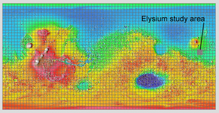
(Excerpted from the MER 2003 GIS Mars data CD, MOLA shaded relief, 5 x 5 degree grid, and Elysium_mdim2.jpg themes checked).
See ArcView Information for the Mars labs to see the elevation color key.
Equipment Needed: Computer with Internet Connection to Class website, calculator, and MER 2003 GIS Mars data stick.
Before attempting this lab, read the ArcView information for the Mars labs.
Objectives: In this lab, you will be examining the geology of one region on Mars that shows a range of landforms and processes typical of the planet, using photogeological techniques and topographic data.
The MER data diskettes
were created to help analyze candidate landing sites for the 2003 Mars
Exploration Rovers. You will be examining the geology of one of the candidate
landing areas (Elysium). The Elysium site is situated north of the lowlands-uplands
boundary, SE of the Elysium volcanic province, and W-NW of the center of
the Tharsis bulge (Fig. 1). The Elysium study area has a relatively
low overall crater density which implies that it consists largely of Amazonian
terrain (Fig. 2).
|
|
Fig. 1. Index map showing
location of Elysium study area.
(Excerpted from the MER 2003 GIS Mars data CD, MOLA shaded relief, 5 x 5 degree grid, and Elysium_mdim2.jpg themes checked). See ArcView Information for the Mars labs to see the elevation color key. |
 |
|
Fig. 2. Overview image of Elysium study area. (Excerpted from the MER 2003 GIS Mars data CD, 5 x 5 degree grid, and Elysium_mdim2.jpg themes checked). |
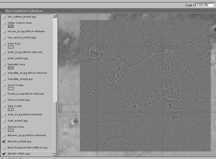
For Part 1, the following themes
in ArcView should be "checked" (from top to bottom): Elysium_mdim2.jpg,
and MDIM1. Click twice on the Elysium theme to make it the active layer
(it will appear raised when active.) "Uncheck" all other themes to speed
up re-draw times.
Q1. [2 points] The main large-scale
landforms in this site consist predominantly of "plains" and knobby terrain
(Fig. 2). The latter is visible near the center of the site at about
208.6 W, 7.6 N and to the east at 201.5 W, 9.4 N (See Fig. 3 for labeled
reference longitude and latitude lines). Zoom in on these two knobby areas
and look at their relationship with the plains. Which is older, knobby
terrain or plains, and how can you tell? (HINT: a key feature is located
in the eastern knobby area.)
Q2. [2 points] What are the likely
origins of the plains and knobby terrain? HINT: Knobby terrain on Mars
is mainly located at the upland-lowland boundary at the transition from
more heavily to less cratered terrains.
Q3. [1 point] The area to
the north shows high albedo wind streaks. What kind of craters served as
the appropriate obstacles to create the wind streaks? Use such terms as
simple, complex, rampart, pedestal.
Q4. [2 points] Cerberus Rupes, a series of graben, occur in the northeast part of the Elysium site. They are located between the Tharsis and Elysium provinces and are roughly radial to both of them (Tharsis is located ~5500 km to the southeast; Elysium is located ~1500 km to the northwest). This implies that the graben formed by the stresses associated with these bulges. When did these graben form relative to the plains and knobby terrain?
Before or after the plains?
Before or after the knobby terrain?
Q5. [2 points] What do your answers
to Q4 imply about the timing of Tharsis- and Elysium-bulge-related tectonic
activity in this area? Specifically, in which part (early or late) of which
geological system would the tectonism have occurred?
Q6. [2 points] Locate the crater
centered at 203.4 W, 8.6 N. What kind of crater is this? Use terms such
as simple, complex, rampart, pedestal.
Q7. [1 point] What does the morphology
of the crater in Q6 imply about the way it formed and about the subsurface
in this area?
Q8. [2 points] Locate the craters centered at the following coordinates on the photomosaic (Elysium_mdim2 layer).
204.44 W, 9.44 N
204.51 W, 8.62 N
205.77 W, 8.39 N
What kind of craters are these? Use terms
such as simple, complex, rampart, pedestal.
Q9. [1 point] Based on the morphology
of the craters in Q8, what must have happened to the distal portions of
their ejecta blankets?
Three areas of differing
albedo (brightness) occur in the Elysium site: mainly low albedo to the
north, mainly high albedo to the south, and a central area with mottled
albedo (Fig. 3). Wind streaks are present especially in the northern
and central areas.
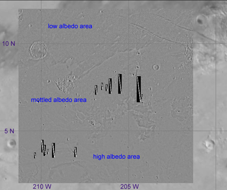 |
Fig. 3. Image showing three areas with differing albedo characteristics within the Elysium study area. Also shown are the locations of high-resolution image strips. Reference longitude and latitude lines are labeled to help you locate specific features . (Excerpted from the MER 2003 GIS Mars data CD, 5 x 5 degree grid, Elysium_mdim2.jpg, and MOC narrow angle image themes checked). |
For the remainder of this lab, the following themes in ArcView should be "checked" (from top to bottom): MOC Narrow Angle (PDS released), MOC Narrow Angle (m23), MOC Narrow Angle (m12-m22), Elysium_mdim2.jpg, and MDIM1. Make the Elysium_mdim2 theme the "active" one by clicking twice on it (it will appear raised). "Uncheck" all other themes to speed up re-draw times.
Note: there are registration errors
of up to a few km between the locations of the hi-resolution images and
the underlying images and maps. All the coordinates given below are those
you will get when you click XY info for the particular image needed to
answer the question.
Consider the mottled albedo central area.
Q10. [2 points] Locate the small
crater at 205.52 W, 7.94 N ("Crater 1"), and zoom in to about 1:30,000
scale. This appears to be a smaller example of the same type of crater
as in Q8. It is located near the boundary between a lower area to the north
and a slightly higher area to the south. Is the rim of this crater older
or younger than the plains immediately surrounding it, and how can you
tell?
Q11. [3 points] Use the pan and
zoom tool (suggested scale: 1:18,000) to take a closer look at the low
surface just to the north of Crater 1 in Q10. This surface is covered by
lava flows. Characterize the surface in terms of albedo, small-scale (<10
m) smoothness, and relative age compared to the rim of Crater 1.
Q12. [3 points] Now use the pan
tool to scroll down the image strip to the slightly higher surface south
of the crater. Look at the surface as you go, and continue moving south
until you get to the wrinkle ridge at ~ 205.51 W, 7.78 N. There is
evidence here (shallow craters, small-scale linear deposits aligned at
an azimuth of ~120 degrees) that windblown sediment covers this area.
Characterize the upland surface between the vicinity of the ridge and Crater
1 in terms of albedo, small-scale (< 10 m) smoothness, and relative
age compared to the rim of Crater 1.
Q13. [2 points] Now move to the
west and zoom in on the small upland located at 206.51 W, 7.61 N. A crater
("Crater 2") occurs in this upland. What does this upland represent and
how was it produced?
Q14. [1 point] What is the term
that describes what the low area surrounding the upland represents?
Q15. [1 point] Lava flows surround
the upland in Q14 and are especially visible north of the upland. What
is the term that describes what these flows represent?
Q16. [1 point] Use the pan tool
to move north to the small pedestal crater ("Crater 3") located at 206.52
W, 7.73 N. Based on evidence found in the image, how was the "pedestal"
of this crater (and for other similar craters) created?
Some of the landforms you have looked at above were created by floods. A low-relief (<< 1 km deep) channel is visible in the topographic maps of this area, and its location corresponds to the lower areas in the northern portions of some of the higher-resolution images in the central area of the Elysium site. The topographic map indicates that the main channel extends from approximately 207.5 W, 7.1 N to 203.1 W, 10.3 N.
For this question only, turn on the Elysium_hs.jpg hillshade theme, and zoom out to the Elysium_mdim2 theme to see the overview. "Cooler" colors (blues, purples) in the hillshading indicate lower elevations, "warmer" colors (reds, oranges) indicate higher elevations.
Q17. [2 points] Looking at the topographic
map (Elysium_hs.jpg), and the apparent flow direction observable in the
high-resolution images, what feature was the apparent source of these floods?
What event(s) evidently triggered the flooding?
Now turn your attention to the high albedo area to the south.
Q18. [2 points] Zoom in on the image
at 208.06 W, 3.94 N. Suggested scale: 1:50,000 or higher. (This image is
offset ~12 km east of the underlying image.) You will see a bright and
lineated "crinkly" upland, and a lower area that contains some streamlined
mesas. Lower albedo lava flows are visible in some of the low areas between
the mesas, although it is difficult to tell from the image whether they
are stratigraphically below (older) or above (younger) the bright material.
What are the two erosion agents that could account for these streamlined
and lineated landforms?
Q19. [1 point] Look at the same
deposit to the west. More streamlined and lineated landforms are visible
at 209.31 W, 3.97 N. These landforms now look more like ridges, and appear
similar to what is found in the Mudusae Fossae Formation, which is a wind-generated
deposit in the equatorial region of Mars in this area and to the east.
If the ridges in the high albedo areas were produced by the wind, what
geologic feature do they represent?
EXTRA CREDIT PORTION OF LAB
Earn up to 0.6% extra to your total grade for the class by completing Part 4 of the lab.
Q20. [3 points] Using all available data, create a stratigraphy column showing the relative ages of the following features: the knobby terrain, the Medusae Fossae Formation (bright plains to the south), the low-albedo plains (to the north), and the mottled albedo plains (in the central area).
Place older units at the bottom, and younger
at the top. If units have about the same ages, indicate this by placing
them at the same vertical position.
Q21. [3 points] Different types
of geologic processes can be associated with each of the four units identified
in Q20. For each unit, associate the types of geologic processes that were
important in their formation. Create a second column in the stratigraphic
column of Q20 labeled "geologic processes" which lists such things as "volcanism",
"tectonism" (graben formation), "flooding", "wind erosion & deposition",
"collapse & erosion of uplands". It is alright to have more than one
process associated with a given unit.
Now let's investigate more closely the chronology of the processes occurring during the formation of the mottled albedo plains. (...After which you are almost ready to write a paper on the geologic history of the Elysium site!)
Q22 (easy). [2 points] Craters 1,
2, and 3 (see Q10, Q13, and Q16 for their coordinates) are located in the
mottled albedo area and have a specific age relationship to the flooding
event that occurred in this area. Did these craters form before, after,
or during the floods in this area, and how can you tell?
Q23 (a bit more difficult). [2 points]
Did Craters 1, 2, and 3 form before, after, or during volcanism in this
area, and how can you tell?
Q24 (still more difficult). [6 points]
Considering your answers to the questions above and to part 2 of this lab,
what is the sequence of events that affected the mottled albedo plains,
considering such processes as volcanism, flooding, wind activity, and the
formation of Craters 1-3? Use Craters 1-3 as a benchmark in time, and draw
a horizontal bar for each process to show the time ranges that the processes
were active relative to this benchmark, going from oldest at left to youngest
at right. Make sure you label each of the bars! Uncertainties in the ranges
can be indicated by question marks.
Chronology for the mottled
albedo plains in Elysium