Name________________________
Equipment Needed: Internet connection to class website and web browser; image software to open and measure lengths on images in units of pixels (Photoshop or Arcview); calculator.
Objective: You will learn about the geology of Europa, Ganymede, and Callisto and infer geological histories for representative areas on these satellites.
To make measurements on images, open the images corresponding to the figures using image software, preferably Photoshop, or ArcView. For information on how to use Photoshop to make measurements, follow these instructions as illustrated for the Io lab. You will need to download the following images to a temporary folder before opening them: galilean-Fig1.tif, galilean-Fig2.tif, galilean-Fig3.tif.
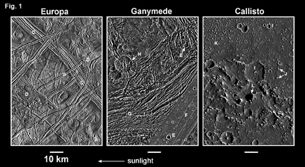
Figure 1 shows representative
Galileo spacecraft images of Europa, Ganymede, and Callisto to the same
scale. The three moons all have surfaces rich in water ice, but very different
geology. This probably reflects differences in their internal structure.
|
Fig.1. Images of Europa, Ganymede and Callisto to the same scale. Each image covers an area of 6600 km2. Sunlight is coming from the right (the sun is to the right). |
1. What is the scale of Fig. 1?
[1 point]
Scale = __________________ km/pixel (report to 2 significant digits)
2. Feature A in Fig. 1 is a sharp-rimmed,
bowl-shaped impact crater. What is the total number of similar impact craters
identifiable in the Europa image in Fig. 1? [1 point]
Total number of craters_______________________
3. The number of impact craters
per unit area (the crater density) on a planetary surface is a rough measure
of the age of the surface; an older surface has a higher crater density.
Using your result from question 2, what is the approximate crater density
on Europa? [2 points]
Crater density on Europa________________________
craters/km2 (report to 2 significant digits)
4. The crater density on Venus is
about 2.1 x 10⁻⁶ craters/km2, and that on Earth's
continents is about 2.2 x 10⁻⁶ craters/km2. How many
times higher or lower is the crater density on Europa compared to that
of Venus and the Earth? Round your answer to 1 significant digit.
[2 points]
5. In order to convert crater density
to an actual age, we need to be able to estimate the number of impacting
bodies per unit time that collided with the surface. This number of impacting
bodies could vary from place to place within the solar system, depending
on the nature and source of the impacting bodies (they could be asteroids,
comets, or other debris swept up by the planets). Do you think it
is meaningful to calculate an age for Europa's surface based on simple
crater density comparisons with Venus and Earth? Provide two reasons
to justify your answer. [2 points]
6. The icy crust of Europa has many
intersecting ridges. Most have valleys running down their centers (ridges
with medial valleys). A typical example is given by feature B in Fig. 1.
How wide is ridge B (from edge-to-edge)? [1 point]
Width of ridge B = _____________________
km (2 significant digits)
7. Ridges on Europa sometimes occur
in groups of closely-spaced, parallel ridges (e.g., feature C in Fig. 1).
Look closely at the cross-cutting relationships between features B and
C. Which do you think (ridge B or the band of ridges centered on C) formed
later, and why? [2 points]
8. Note that ridge B intersects
on both ends a different type of landform on Europa (feature D in Fig.
1), characterized by a bumpy or hummocky surface topography. Which unit
(B or D) is younger, and how can you tell? [2 points]
9. Look carefully at the pattern
of ridges surrounding unit D in Fig. 1. Based on this pattern, is there
any evidence for horizontal displacement of ridges across unit D? [1 point]
10. Impact craters are present on
Ganymede (e.g., feature E in Fig. 1). Estimate how the crater density on
Ganymede compares with that of Europa, by saying whether it is about the
same (within a factor of three) as Europa, significantly less than Europa,
or significantly more than Europa. [1 point]
Crater density on Ganymede____________________________________
11. Ganymede contains both relatively
smooth plains (feature F in Fig. 1), as well as a rougher terrain that
has been tectonically deformed, which has many ridges and valleys- so-called
"grooved terrain" (feature G). Based on cross-cutting relationships, can
you tell which terrain (F or G) is older, and if so, which one? [1 point]
12. Which unit (F or G in Fig. 1)
appears to have a higher crater density, and does this observation seem
to support or refute the relative age determination you made in question
11? [2 points]
13. Two larger circular features
(feature H and a smaller one immediately to the lower left of H in Fig.
1) occur in an area that has many fractures. Are these circular features
depressions or elevations, and what do you think they represent? [2 points]
14. Based on the subdued and almost
unrecognizable appearance of feature H, do you think that this feature
would be visible if it had experienced tectonic deformation of the sort
that occurred around the letter "G" in Fig. 1? [1 point]
15. Does your answer to question
14 resolve the relative ages of units F and G? Explain. [2 points]
16. Voyager spacecraft images of
Callisto led to the description of Callisto being "the most heavily cratered
surface in the solar system". A more accurate description is that Callisto
is one of the most uniformly cratered places in the solar system; the crater
density doesn't vary much from place to place. Higher resolution images
of Callisto obtained by the Galileo orbiter (Fig. 1) show small and medium-sized
craters (e.g., feature I). Looking at Fig. 1, estimate how the crater density
on Callisto compares with that of Europa and Ganymede, by saying whether
it is about the same (within a factor of 3) as Europa and Ganymede, significantly
less, or significantly more than Europa and Ganymede. [2 points]
Crater density on Callisto compared to
Europa______________________________________
Crater density on Callisto compared to
Ganymede___________________________________
17. Considering your answer to question
5, do you think it is meaningful to determine relative ages of surfaces
on the Galilean satellites by simple comparison of their crater densities?
Why or why not? [2 points]
18. Based on your answers to questions
16-17, do you think that Europa, Ganymede, or Callisto has the youngest
surface on average? Which has the oldest surface on average? If you can't
tell for sure based on Fig. 1, indicate this. [2 points]
The youngest surface of the three________________________________________________
The oldest surface of the three__________________________________________________
19. Callisto also has many hills
(feature J). Based on your knowledge of the sun direction, how would you
describe the landscape in region K? [1 point]
20. If the features labeled J are
hills, what is feature L? HINT: look at the lengths of the shadows. [1
point]
21. Is there any evidence for tectonic
deformation (producing ridges and valleys) on Callisto as there is for
Ganymede? [1 point]
22. Speculate as to the origin of
the numerous hills on Callisto. HINT: Look around feature I. [2 points]
23. Based on your answers to questions
18-22, summarize the geologic history of this portion of Callisto. Be sure
to discuss the relative ages of craters and hills and the relationship
between them. [3 points]
Figure 2 shows an image of
Europa obtained by the Galileo orbiter that provides some of the most compelling
evidence that large amounts of liquid water were present on Europa's surface
recently.
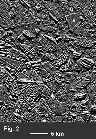 |
Fig. 2. This area of so-called "chaos" terrain on Europa shows plate-like features (e.g., feature A) that contain ridges and valleys, and a bumpy or hummocky terrain (e.g., at B) that appears to enclose, and to be lower than, the plates. In some areas (e.g., at C), obvious examples of horizontal displacement can be seen between adjacent plates. Sunlight is coming from the 12:30 position. |
24. What is the scale of Fig. 2?
[1 point] Scale of Fig. 2 = __________________ km/pixel (2
significant digits)
25. What is the maximum length of
plate A? [1 point]
Length of A = ________________________
km (2 significant digits)
26. How much horizontal displacement
occurred between adjacent plates at C? [1 point]
Displacement at C = ______________________
km (2 significant digits)
27. Which of the two major terrain
types, plates or hummocky terrain, do you think is older and why? [2 points]
28. Based on the appearance of the
plates and hummocky terrain and the evidence for horizontal displacement
of the plates, what do you think the plates represent? Think of one
word. [1 point]
29. Considering your answer to question
28, what does the hummocky terrain represent? [1 point]
30. How many sharp-rimmed, bowl-shaped
impact craters do you see in Fig. 2? [1 point]
Number of craters____________________
31. Do these craters seem to occur
mainly on the hummocky terrain, or on the plates? [1 point]
32. Is your answer to question 31
consistent or inconsistent with your answer to question 27? [1 point]
33. Feature D in Fig. 2 is a canyon
that extends across most of the image, from the upper right to the lower
left. Based on cross-cutting relationships, is canyon D a younger or older
feature compared to the plates and hummocky terrain? [2 points]
Age of D compared to plates_______________________________
Age of D compared to hummocky terrain___________________________
34. Based on your answers to questions
27-33 and superposition relations, summarize the geologic history of this
portion of Europa (Fig. 2) by creating a stratigraphic timeline, placing
older features at the bottom and younger at the top. If relative ages are
uncertain, indicate this by placing features at the same vertical position.
In your stratigraphic sequence include the following: plates, hummocky
terrain, ridges on the plates, canyon D, impact craters. [4 points]
Among the Galilean moons, the one that shows the most diversity of ages on its surface is Ganymede. Europa contains a few impact craters but no heavily cratered areas; and Callisto has a fairly uniform crater density. (Io, the fourth Galilean moon, has no impact craters at all.) Ganymede has both heavily cratered portions and areas with few impact craters. Figure 3 shows a regional view of Ganymede that illustrates the major terrain types and their relationships on this planet-sized moon.
Terrain types in Fig. 3:
A = heavily cratered area
B, C, D, E = light-colored, smooth plains
F, G, H, I = light-colored, "grooved"
terrain, consisting of parallel ridges and valleys
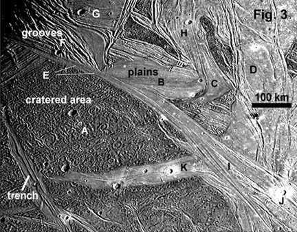 |
Fig. 3 Image of Ganymede illustrating terrain types. Sunlight is coming from the 3:30 direction. |
35. Area A in Fig. 3 is the most
heavily cratered, and it is cut by all other units, indicating that it
is the oldest unit. Based on crater density, are the smooth plains (B,
C, D, E) generally older or younger than the grooved terrain (F, G, H,
I)? [1 point]
36. Note that the grooved terrain
at feature I in Fig. 3 appears to merge into the smooth plains at E, and
that the grooved terrain in feature H appears to merge into smooth plains
at C. Assuming that the grooved terrain contains faults along which water
could have moved to the surface, how could units E and C have formed? [3
points]
37. Looking especially at the narrowness
of feature E in Fig. 3, do you think that any water erupting to the surface
to form the smooth plains flowed freely across the surface, or was it confined
to localized areas only? [1 point]
38. Considering your answers to
questions 37 and 29, which moon, Europa or Ganymede, is more likely to
have had large bodies of spatially extensive, and relatively deep liquid
water on the surface? [1 point]
39. Considering your asnwers to
questions 38 and 18, which moon, Europa or Ganymede, experienced more internal
heating? [1 point]
40. On Ganymede, impact craters
in grooved terrain or smooth plains often show high-albedo ejecta (J and
K), whereas bright ejecta never occurs around craters in the cratered terrain.
Assuming that the crust of Ganymede consists of bright water ice + darker
non-ice components, what does this imply about the composition of crust
below
the surface in heavily cratered terrain, grooved terrain, and the smooth
plains? [3 points]
41. Using superposition relationships
and your answers to questions 35-38, construct a stratigraphic timeline
for the formation of features A-K in Fig. 3, placing older features towards
the bottom and younger features towards at the top. If age relationships
are uncertain, indicate this by placing features at the same vertical position.
[3 points]