“When to raise and when to fold.”
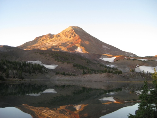
After I carried my
light pack over Middle Sister to Camp Lake, just below the saddle
between South Sister and Middle Sister, I decided I would try the north
route up South Sister. I spent a pleasant evening looking across
the lake at the ridge I would go up the next morning. In the
photo, taken from my camp site at sunrise, the route I planned to take
follows approximately the line between the sunlit side and the shadow
side.
The night
was quite beautiful, and I was glad I was sleeping in the open. Even with the nuisance of having to put on
glasses to see them the stars are intense at that elevation, and I saw
several
shooting stars during periodic spells of wakefulness.
I was also reminded of why I carry the extra
weight of a 2 inch, extra wide sleeping pad.
Well before 8:00 it was too dark to do anything but go to bed,
and when
I arose at 6:00 I had to fumble around in the dark for a half hour
before there
was anything you could actually call “light.”
Even with my old 1 inch sleeping pad the longest I was ever able
to stay
in the sleeping bag was seven hours – and by that time it felt like my
legs,
arms, and hips were all turning into lumpy mush. Several
times during the night I heard the
explosive clatter of rocks falling from the cliffs to the east of the
route I
planned.
By the time
I finished coffee and breakfast it was apparent that it would be a
great
day. I emptied my pack so I could use it
for water, snacks, and the necessary survival gear (including my
Personal
Locator Beacon, which I hope never to use).
I shouldered this much lighter pack and headed back up the trail
to the
ridge-line, which I followed through the sparse stands of timber to the
foot of
the actual peak. There I picked up a
trail that had clearly been followed by many other climbers.
The first
half of the climb is pretty straightforward and easy – a series of
almost level
knolls, separated by steep slopes of rock and sand, but much firmer
than that
on Middle sister. There are two serious
obstacles on the ridge. 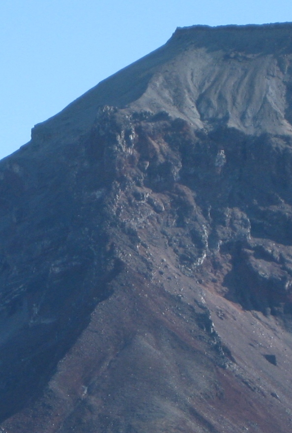 The
top-most is
a buttress, several hundred feet straight up, that stands out from the
rounded
top of the mountain. The mountain itself
is crowned with a wall of stone – it resembles the low fortress walls
the Celtic
tribes built. Once you are atop the
buttress, the climb to the ring of rocks at the top is a relatively
gentle
slope, maybe 100 - 200 feet of elevation gain.
However, without skill and gear that I lack, the buttress itself
is
impassable.
The
top-most is
a buttress, several hundred feet straight up, that stands out from the
rounded
top of the mountain. The mountain itself
is crowned with a wall of stone – it resembles the low fortress walls
the Celtic
tribes built. Once you are atop the
buttress, the climb to the ring of rocks at the top is a relatively
gentle
slope, maybe 100 - 200 feet of elevation gain.
However, without skill and gear that I lack, the buttress itself
is
impassable.
A second obstacle, extending from the base of the buttress for several hundred feet down the ridge, is a jumble of boulders, arranged like a staircase for giants, with “risers” that appear to range from two to four or five feet. The route description I read recommends a detour around this jumble of rocks, up a couloir filled with a blend of loose sand, gravel, and rocks ranging in size from a baseball to a watermelon – some of these are relatively stable, others come loose if you put much weight on them, and it is often unapparent which ones are stable. The slope is sufficiently steep that, once a rock comes loose, it rolls, tumbles, and bounces all the way down – at least 1000 feet. You would not want to follow another climber up this route, and it requires obvious care. The jumble of boulders, seen from the couloir, is a sheer wall ranging from ten to fifteen feet high, with a few breaks where it is just possible to get down from it or back up onto it. This wall leads off to the west from the main ridge; it is where the ridge narrows, just below where the rocks rise above the sand and gravel of the main ridge (referred to as the “crux”) that descent off the ridge and into the couloir was recommended.
At the top of the couloir, at about where the jumble of rocks comes up against the main buttress, a string of smaller buttresses stretches out toward the west. These are arranged in a way that it appears to be relatively straightforward to work one’s way through them, to the much less steep slope that stretches on up to the mountain’s rocky crown. The main challenge appears to be reaching the base of these smaller buttresses.
Partly because it wasn’t clear where the wall would best be descended, I followed the rock outcropping up for probably 100 feet. I stopped at a point where I would need to use a narrow, 4 inch wide ledge to lever myself up a 5 foot riser onto a level rock above. I have clambered up more difficult boulders, but the platform at the bottom was itself not much wider than a foot, with a steep descent below, hence trickier to get down than to get up. Once on top of this obstacle it looked like easy clambering to the main buttress – but I’ve been suckered by that kind of situation too many times. I decided that this was not a good idea for a solo hiker, turned back, and found a place to get down into the couloir and try that route.
At first it was
relatively
straightforward. The occasional rock
tumbling down the mountain until it was out of sight was a bit
unnerving, but
it was easy enough to get good footing in the sand and gravel, so I
wasn’t
particularly worried that I would follow the rocks down this path. However, as I ascended, it got trickier. There were patches of excellent footing –
rock surfaces well anchored in the mountain-side that afforded good,
secure
footing. But a few of these had either
rotton patches, that broke off if you put weight on them, or bits of
loose
gravel on their surface, that rendered them entirely useless. 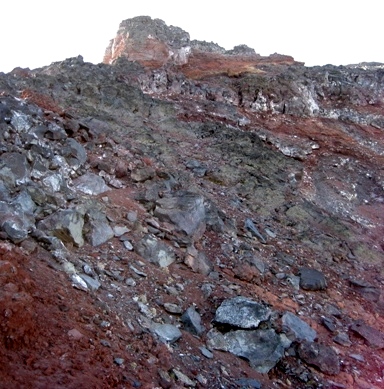 At this
point, I was tantalizingly close to
the top of this difficult stretch, only a couple of hundred yards below
the
series of low buttresses that guard the gate to the mountaintop. However, I was also becoming increasingly
uneasy about my footing. I stop every 15
feet or so to look back down what I have just climbed to see how I will
feel
about going back down the same route – and when I looked back downward,
I
realized I was not at all comfortable about the 50 or 100 feet of slope
immediately behind me. So I sat down on
one of the few level, stable boulders in the vicinity, had a drink of
water,
looked up the slope to the immediate objective (with the ultimate
objective,
the rocky crown of the mountain itself, just visible above the
buttresses),
then looked down the slope toward what I would have to pass over in
order to
get back to my camp and my gear.
At this
point, I was tantalizingly close to
the top of this difficult stretch, only a couple of hundred yards below
the
series of low buttresses that guard the gate to the mountaintop. However, I was also becoming increasingly
uneasy about my footing. I stop every 15
feet or so to look back down what I have just climbed to see how I will
feel
about going back down the same route – and when I looked back downward,
I
realized I was not at all comfortable about the 50 or 100 feet of slope
immediately behind me. So I sat down on
one of the few level, stable boulders in the vicinity, had a drink of
water,
looked up the slope to the immediate objective (with the ultimate
objective,
the rocky crown of the mountain itself, just visible above the
buttresses),
then looked down the slope toward what I would have to pass over in
order to
get back to my camp and my gear.
In my classes I
sometimes teach
about the principle of “sunk costs,” how one can be tempted to “redeem”
a
series of bad decisions by making even more bad decisions.
I did not yet feel bad about any of the
decisions I had made, except perhaps the decision to climb the last 50
feet
over this unstable and treacherous footing, but I decided not to let
the
proximity and apparent attainability of my objective sway my judgment. The best decision would be to throw in the
towel, admit that the mountain had defeated me, and turn back. That’s what I did. The picture was taken
at approximately the point where I turned around. The summit can
be seen at the upper right corner, peering out above the
buttresses.
The descent down that last 50-100 feet was as hairy as I had feared, but after that it was just a matter of one glissade after another, always careful to maintain balance, down the long slope, gravel and rocks of every size tumbling down the mountain ahead of me. Several hundred feet down the mountain I passed the place where I had descended into the couloir, but I decided to go a few hundred yards farther before clambering up through a break in the rock wall. At that point I was already well below the crux, so had to side-hill across a long slope back to the main ridge – all quite straightforward. By this time I was feeling quite good about the decision I had made to give up on it. I was clearly in over my head, and quitting was the best decision.
I made it back to my
camp site
about 11:30, took off my boots, sat down for a bite of lunch, then
packed my
gear back into the back-pack and, a bit after noon, set out for my next
planned
campsite, where the around-the-mountain trail crosses Alder Creek. It was a great hike, even if I didn’t make
the summit!
Back to original page.