|
Joseph Maser |
Nehalem
River Watershed Assessment |
Chapters
Contents1.0 Introduction
2.0 Historical Conditions
3.0 Channel Habitat Types
4.0 Hydrology and Water Use
5.0 Riparian Conditions
6.0 Sediment Sources
7.0 Channel Modifications
8.0 Water Quality
9.0 Fish and Fish Habitat
10.0 Watershed Conditions Summary
Home
Projects
PSU
ESR Dept.
Purpose
Watershed assessment is a process for evaluating how well a watershed is working. The purpose of this assessment was to determine how natural and human-induced changes have impacted the sustainability of salmon populations in the Nehalem River Watershed. Both historical and current information is included regarding the watershed’s ability to produce clean water and healthy salmon habitat.
The assessment was prepared for the Upper and Lower Nehalem River Watershed Councils. It will be a baseline for developing and prioritizing potential restoration projects in terms of fish habitat. Geographic Information Systems (GIS) was used for much of the analysis and has been provided to the watershed councils.
GWEB Draft Oregon Watershed Assessment Manual
The assessment followed the procedures and guidelines described by the Governor’s Watershed Enhancement Board’s (GWEB) January 1999 Draft Oregon Watershed Assessment Manual. The riparian conditions component was started prior to 1999 and reflects the methodology described in the 1998 draft manual. The GWEB manual provides a consistent way of conducting watershed assessment. It is a framework for using existing data to evaluate important watershed components including historical conditions, channel habitat types, hydrology and water use, riparian conditions, sediment sources, water quality, channel modifications, and fish and fish habitat. Gaps in available data are identified and a summary of watershed conditions is included with recommendations for potential restoration projects.
Background
Physical Location
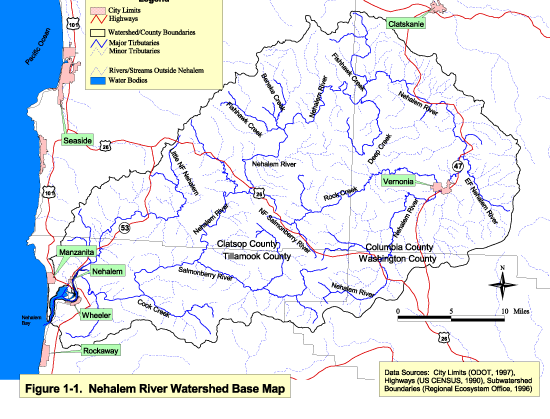
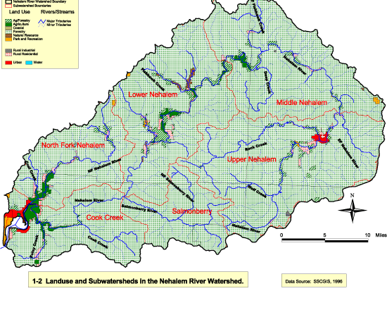
The Nehalem River Watershed is located on the Oregon Coast. It lies completely within the temperate coniferous rain forest belt. Historically, the basin was dominated by old growth coniferous ecosystems with marshlands in the lower gradient areas and estuaries (Kostow, 1995). It is 855 square miles and includes portions of Washington, Columbia, Clatsop, and Tillamook Counties. The Nehalem River is 118.5 miles long and originates on the east side of the Coast Range and circles around the northern tip of the mountains before draining into Nehalem Bay and then the Pacific Ocean. See Figure 1-1 for the watershed location and boundary. There are many large and small tributaries totaling over 935 miles in length. The watershed is divided into six subwatersheds which are used in much of this assessment to summarize findings at a smaller scale (See Figure 1-2).
Watershed elevations range from sea level at the mouth of the Nehalem River to nearly 3,200 feet in the Coast Range near the Salmonberry River. Other distinguishing features include the towns of Nehalem, Mohler and Wheeler concentrated around Nehalem Bay and other small communities scattered through the watershed including Vernonia, Jewell, Birkenfeld, Timber,
Mist, and Pittsburg. State Highway 26 runs east and west through the middle of the watershed connecting the watershed communities with Portland.
Population
The Nehalem Watershed is sparsely populated. While there are rural residences in some areas along the mainstem Nehalem River, North Fork Nehalem River and other major tributaries, the only incorporated cities are Nehalem and Vernonia. Nehalem has a population of 200 people and has declined in population since 1990 by 15%. Vernonia has a population of 2,420 and has increased in population since 1990 by 34% (Center for Population Research and Census, 1999).
Geology
Geological materials found in the watershed are volcanic and sedimentary rocks. These rocks were formed during the Eocene and Oligocene ages of the Tertiary period. The volcanic rocks are mainly basaltic lavas and tufts with sedimentary rocks at shallower depths of shale, claystone, sandstone, and siltstone (NRCS, 1998).
Land Use
Most of the land in the Nehalem Watershed is either state or privately owned (98%). Some small plots comprising 2% of the watershed land belongs to the Bureau of Land Management The state of Oregon owns 38% of the land which was mostly acquired following the Tillamook burn (SSCGIS, 1996). Sixty percent of the watershed is privately owned. The largest private land owners are Longview Fibre (35% of private land) and Willamette Industries (28% of private land). Both companies use the land for timber resources. Many small plots of land owned by individuals are located along the Nehalem River and its major tributaries. These comprise 21% of the private land in the watershed. The remaining portion of the private land is owned by other timber companies.
Forestry is the major land use activity in the watershed (92% of land). Land used for agriculture comprises about 4% of the watershed area and is located in the low gradient areas in the lower and middle watershed. Urban areas only account for 0.5% of the total watershed area (SSCGIS, 1996). Figure 1-2 shows the land use distribution.
Vegetation
Types and Distribution
The vegetation composition in the watershed varies with topography and timber harvest history. The lower elevation areas, especially bordering the mainstem Nehalem River are dominated by stands which are more than 70% broadleaf species or are mixed broadleaf and medium sized (25-50 cm diameter) conifers. The higher elevation areas of the Coast Range are dominated by medium (25-50 cm diameter) and large (51-75 cm diameter) conifer stands.
|
|
Figure 1-1 Click image to see full size image. Use you back button to return. |
|
Figure 1-2 Click image to see full size image. Use you back button to return. |
Swiss Needle Cast
Swiss Needle Cast (Phaeocryptopus gaeumannii) is caused by a chronic fungus which affects only Douglas fir trees. The fungus has been an endemic species for thousands of years and until recently remained fairly at a level which did not cause significant loss of trees. Since the late 1980’s, Swiss Needle Cast has become increasingly severe, particularly along the north coast of Oregon.
Symptoms of Swiss Needle Cast include discoloration of the needles, needle loss, and reduced tree height and diameter growth. The loss of older needles caused by the disease allows increased light levels to reach the forest floor which results in a dense understory of brush.
The Oregon Department of Forestry and the U.S. Forest Service have conducted annual aerial surveys since 1996 to determine the extent of Swiss Needle Cast. The severity of the disease has increased in the Nehalem Watershed from 1998 to 1999 (See Figures 1-3 and 1-4). The North Fork Nehalem River and Cook Creek areas appear to be the most affected. Most of the discoloration observed occurred within about 15 miles of the coast, however symptoms were noted extending 24 miles inland from the coast. The disease seems to be prevalent where fog frequently occurs.
The reason for the sudden increase in Swiss Needle Cast is unknown, but the most likely hypothesis is that management practices, in combination with a climate conducive to the disease, have shifted the ecological balance in favor of the disease (ODF, 1998). Historically, plantings were often done using seeds collected from farther inland, higher elevation areas. Trees from these seeds would have the resistance to Swiss Needle Cast that native coastal trees would have. Also, Douglas fir seedlings have been planted in areas which were historically hemlock and spruce, so the geographic range of Douglas fir may be more extensive than previously.
ODF current forest management policy involves planting species other than Douglas fir in severely affected areas and limiting the proportion of Douglas fir to 50 percent or less where disease is noticeable but not severe (ODF, 1998).
Watershed Issues
Issues of concern were identified when this assessment was initiated. Those identified by watershed council members and the ODFW (1993) follow:
· Water temperatures in much of the mainstem Nehalem River and several major tributaries exceed desired temperature thresholds in summer months.
· Low summer streamflows in the Nehalem River limit salmon habitat.
· Sediment related to forestry activities have negative impacts on water quality and fish habitat.
· There is a widespread lack of large woody debris in the watershed.
· Improper installation, undersizing and lack of maintenance of culverts may be limiting fish passage.
This assessment addresses these concerns. Additional data needed is discussed in each section and in the watershed condition summary, along with recommendations for potential restoration.
References
-
Center for Population Research and Census (1999). Population of Counties and Cities in Oregon: December 17, 1999. Portland State University, Portland, Oregon.
-
Kostow, K. 1995. Biennial Report on the Status of Wild Fish in Oregon. Oregon Department of Fish and Wildlife.
-
Natural Resources Conservation Service (NRCS). 1998. Soil Survey Geographic Database. U.S. Department of Agriculture, Fort Worth, Texas.
-
Oregon Department of Forestry (ODF). 1998. Swiss Needle Cast of Douglas fir in Coastal Western Oregon. Forest Health Program, Salem, Oregon.
-
Oregon Department of Fish and Wildlife. 1993. Draft Nehalem Basin Plan.
-
State Service Center for GIS. 1996. Forest Land Ownership of Western Oregon. Salem, Oregon.
-
State Service Center for GIS. 1996. Land Use Zoning for Northwestern Oregon. Salem, Oregon.
| Maintained by Joseph
Maser |