http://web.pdx.edu/~rueterj/courses/esr220/lab/tidewood-johnson.html

MIDDLE FANNO CREEK |
|
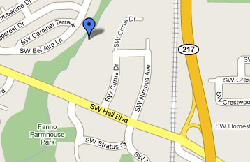
Location:The stream runs to the west of 217. You can find access to the greenway from Hall Boulevard, parking either on the south side of Hall in the Albertson's lot or on the north side of the road before the stream in a parking lot shared by McMennamins.
|
 |
There is a bike path running through the greenway. |
|
Interesting points:This stream flows south at this point and goes under several highway bridges. The bridge near this sampling point is pretty sketchy, but further down when the stream goes under Scholls Ferry, the stream is open and accessible. I usually stay out from under bridges.
|
|
Possible sampling points:The banks of this stream are blocked with berrys and steep. Just past the foot bridge there is a possible access point that has concrete over rocks down to the stream, see below. |
|
|
Links to other data and references:1. nearest USGS gaguing and monitoring sites are:
2. More information on the restoration effort is available from:
|