
http://web.pdx.edu/~rueterj/courses/esr220/lab/balch-creek.html
|
|
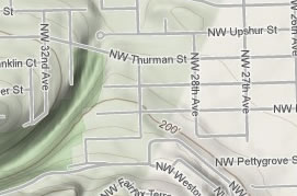
Location:Balch Creek comes down a canyon from NW Skyline Boulevard near Cornell, crosses under the NW Thurman Street Bridge and flows into Lower Macleay Park. To get there, go west on Thurman to 28th and cut over to Upshur and go to about where 30th would be. You can reach it from PSU by Trolley to Northrup and 23rd and then (U - N) + (30 - 23) blocks. The Wildwood trail also crosses Balch Creek at the stone house.
|
 |
|
Interesting points:Balch Creek has an interesting and colorful history, including Hatfield-McCoy type feuds and murders. In the past, the creek was modified to conform with a particular image of how nature should be. The stone work and channelization were all thought to enhance the beauty of the natural stream for Portlanders taking a stroll after cruising around in their horse and buggy. When I was a kid, there was no woody debris and the stream babbled over rocks. I doubt there were any trout in the stream at that time. |
Possible sampling points:
|
|
Management and conservation issues:Balch Creek runs through a very steep canyon that is under development pressure at the higher elevations and continued, older pressure nearer Thurman. People are discussing, or arguing about the impact of houses on turbidity and stream health. The trout that swim up Balch Creek must be pretty tough. They start out in the Willamette in an area with many superfund sites and swim in a culvert all the way under the industrial district to the park.
|
Links to other data and references:1. nearest USGS gaguing and monitoring sites are: 2. nearest weather station 3. More information on the restoration effort is available from:
|