Lecture Notes - GIS for the Natural Sciences
Pedagogical Structure, etc
-
The difference between learning GIS and learning GIS
software
-
Learning by doing
-
Teaching vs Learning
-
My background
-
History of this class
-
Grading the term
Basic GIS
-
Representing things (example)
-
Points, Lines, Polygons, Raster, Tin, Attributes
(like spreadsheets!)
-
Measuring things
-
Categorical -discrete
-
Ordinal - discrete with order
-
Continuous - quantitative
-
-
2 problems: file formats and coordinate systems
-
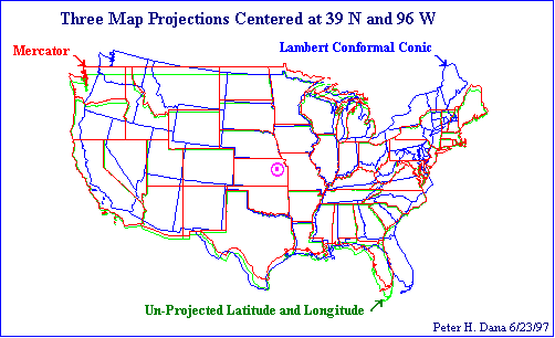
WGS84
vs NAD83
-
-
-
NAD 27/NAD83 (North American Datum)
-
Why different coordinate systems?
-
Minimize distortion in area and/or angle
-
Parameters used in defining a projection
or coordinate system
-
Converting DMS
to DD
-
Reprojecting data: within the same Datum
vs different Datum!
-
"On-the-Fly" vs "Physical" reprojection, and the
Data Frame
-
Data Frame [CRS/SRS/Projection] defined by first
added Object (as long as Object has SRS defined!)
-
Defining the Projection
-
Storing Data
-
Converting Data
-
Resampling Data (Continuous vs Categorical) some
details
-
Selecting Data (SQL Select)
-
Symbolizing or classifying data (covered in
tutorial, right?)
-
Scale: "large" vs "small", remember that ratio is
like dividing
- 1523 vs 8341 glaciers from 1:100K vs 1:24K
-
Maps as Models vs modeling physical systems
-
Types of Purposes (coastal erosion example)
-
Organization
- basic database construction, warehousing large
amounts of data, ongoing updates
-
Visualization
- visual display of data shows patterns not evident
in tables of data (duh!), spatial display shows
patterns not evident in graphs!
-
Spatial Query
- show me all places where "X > Y". identify
objects, ie "what is this thing?" (Arcview examples)
-
Combination
- also overlay analysis (often vector)
- map modelling, eg, intersect (impose in
Bonham-Carter), example: soils and geology
- combine values from different layers with
algebraic statements (often raster)
- subset of geoprocessing, ie union, intersect
-
Analysis
- wide open, tons of possibilities
- spatial analysis takes into account the spatial
relationships, standard statistical analysis
typically does not
- single map vs multiple map
- modeling
-
Prediction
- perhaps the ultimate goal in science!
- detailed example from Bonham-Carter
Some
map types for area data or thematic mapping
other
tools
- Lineage
- Positional Accuracy
- Attribute Accuracy
- Logical Consistency
- Completeness
Anatomy of a GIS Dataset
- Shapefile
- Coverage
- Geodatabase
- Raster Imagery
Databases
-
Terminology: tables, fields, records, indexes, joins
-
Relational vs Hierarchical vs OO (object oriented)
-
SQL (structured query language)
-
Foreign key, or how do I relate multiple tables
-
levels of "Normality", or "Do I sacrifice usefulness
for Elegance?"
- bad
example, good
example
Useful stuff for scientists
-
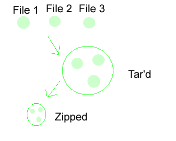
Downloading and unzipping files (illustration)
-
Creating basemaps
-
Creating basemaps to put your own data on
-
Finding basemap layers
-
Creating your own data: Digitizing, GPS, etc
-
Scale issues, microscopic to intergalactic
Analysis, the payoff!
-
Too tired!
-
Independence and Randomness
-
Analysis of point, line and polygon patterns
-
Geostatistics
-
-
Raster analysis, con() function, other algebraic
functions
-
Directional or Orientation analysis
-
What can be done, vs what is useful, ie, computing
power makes algorithms do-able, not always meaningful
From de Smith book:
- Core components of geospatial analysis, including
distance and directional analysis, geometrical
processing, map algebra, and grid models
- Exploratory Spatial and Spatio-temporal Data Analysis
(ESDA, ESTDA) and spatial statistics, including spatial
autocorrelation and spatial regression
- Surface analysis, including surface form and flow
analysis, gridding and interpolation methods, and
visibility analysis
Extending the GIS
-
Limitations of commercial GIS
-
GIS as a platform for modelling and analysis (vs
programming from scratch...)
-
Where to look for extensions
-
Simple programming structures to "roll your own"
algorithm
Sharing using standards
-
OGC
standards body
-
-
WMS vs
WFS, the raster/vector paradox on the web!
-
What about KML?
-
Mashups! Fun for all!
end
|