Location and Environment * Chinookan Culture * Chinookan Material Culture
Site Chronology * The Plankhouse * The Meier Site Excavations * Features * Artifact Photo Gallery


Site Chronology * The Plankhouse * The Meier Site Excavations * Features * Artifact Photo Gallery
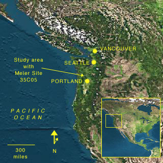
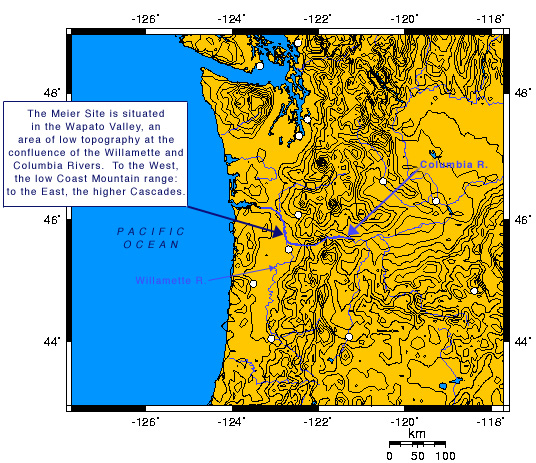
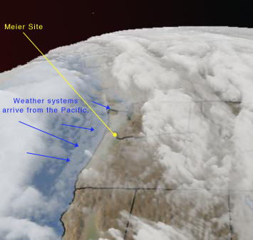
GeographyThe Wapato Valley (WV) includes the region along the Columbia River from the Sandy River downstream to the Cowlitz River. It thus includes the greater Metropolitan areas of Portland, Oregon and Vancouver, Washington. The major physiographic features of the basin are the Columbia and Willamette Rivers. The study area encompasses the Willamette River north (downstream) from its falls at Oregon City to its confluence with the Columbia River. The main branch of the Willamette enters the Columbia at Portland. Dixie Mountain is the highest elevation in the area at 484 meters above sea level (ASL). The area can otherwise be divided into two topographic sub-areas: (a) the alluvial bottom lands along the shores of the Columbia River and (b) the higher plateau or table lands of East Portland, which rise to elevations between 75 and 90 meters ASL, and Clark County. Most archaeology has focused on these bottom lands since they are where the late prehistoric population of the area was concentrated. There has been ongoing, but poorly reported, work in the Clark County uplands over the past 30 years. The valley is part of the Puget-Willamette Lowland, which is the southerly end of the Coastal Trough that runs from southeast Alaska through to the south end of the Willamette Valley. The Puget-Willamette Lowland is the only portion of the trough that is not currently drowned by sea water. The outer mountains separate the trough from the Pacific Ocean. In western Oregon, the outer mountains are the Coast Range, while in Washington the outer mountains include the low Willapa Hills. The trough is flanked on the east by the Cascade Range. The Willamette Valley and the Wapato Valley have a humid climate with low summer precipitation. The majority of precipitation falls between November and March. In the summer months, there is typically little rainfall. There is minimal diurnal temperature variation and the variation between minimum and maximum seasonal temperatures ranges from 0deg C (32deg F) in January and 29deg C (81deg F) in July. The area has long growing seasons. The Portland area has an annual frost free period of over 200 days. Annual precipitation in the Portland area varies between 33 and 45 inches (838 to 1143 mm.). Some stations have much higher rainfall, ranging from 55 inches (1400 mm) to over 90 inches (2300 mm) of rain near the Columbia Gorge. The mean summer or July temperature is around 14o C on the coast and 15deg C inland. Flora and Fauna The vegetation of the Wapato Valley falls into Franklin and Dryness' Pinus-Quercus-Pseudotsuga Zone. Along the rivers are riparian forests of Black cottonwood (Populus trichocarpa), Oregon ash (Fraxinus latifolia), Bigleaf maple (Acer macrophyllum), Oregon white oak (Quercus garryana), Red alder (Alnus rubra), and Ponderosa pine (Pinus ponderosa). Oak woodlands dominate the zone's forests and savannas. Riparian communities and poorly drained areas generally host a variety of minor hardwood species. Conifer forests become predominant in the foothills of the interior valleys. The most abundant species found are Douglas fir (Pseudotsuga menziesii), Grand fir (Abies grandis), and Ponderosa pine. Western hemlock (Tsuga heterophylla) is almost absent from the Willamette Valley and can only be found along its periphery. Western red cedar (Thuja plicata), which can sustain itself in dry climates, is concentrated in the area near Portland. Palaeoenvironmental reconstruction of the flood plain indicates it was a remarkably patchy environment, with seven habitat types, six of which were on the flood plain proper. It is clear that this was an extremely productive environment. The Wapato Valley was home to a rich array of terrestrial and aquatic mammals, as well as fish and birds. Riverine species include fish such as sturgeon and salmon; mammals included beaver (which was hunted extensively after the arrival of Europeans), elk, deer, bear, a variety of carnivores and rodents. The wide range of plant species included wapato (the bulbs of which were processed and eaten, similar to potatoes) and camas (an upland plant also with edible bulbs.) Slightly modified FROM:
Archaeological Investigations (1991-1996) at 45Cl1 (Cathlapotle), Clark County, Washington. A Preliminary Report.
by Kenneth M. Ames, Cameron M. Smith, William L. Cornett and Elizabeth A. Sobel.
January 1999 Wapato Valley Archaeology Project Report #6.
Department of Anthropology
Portland State University & U.S. Fish and Wildlife Service.Click HERE for an online version of this report (including bibliographic references).
csmith@sfu.ca