|
Joseph Maser |
Nehalem
River Watershed Assessment |
Chapters
Contents1.0 Introduction
2.0 Historical Conditions
3.0 Channel Habitat Types
4.0 Hydrology and Water Use
5.0 Riparian Conditions
6.0 Sediment Sources
7.0 Channel Modifications
8.0 Water Quality
9.0 Fish and Fish Habitat
10.0 Watershed Conditions Summary
Home
Projects
PSU
ESR Dept.
This analysis provides a screening-level assessment of water quality parameters in the Nehalem River watershed. The purpose is to identify obvious areas of water quality impairment by comparing selected measurements of water quality to evaluation criteria. Human activities and natural processes determine the water quality at a given site and time. Land uses such as timber harvest, agriculture, mining, channel modifications, and urbanization effect water quality. Naturally occurring processes such as climate, hydrology, erosion, and vegetation types effect water quality as well.
Methodology
GWEB Guidelines for assessing water quality involved collecting information about beneficial uses, 303(d) listed reaches, and other water quality data collected by DEQ and the Nehalem Watershed Councils. Data was evaluated based on Oregon Water Quality Standards.
Impairments due to particular parameters (temperature, dissolved oxygen, pH, nutrients, bacteria and turbidity) were identified according to the GWEB protocol: <15% of samples exceeded the standard = no impairment, 15-50% = moderate impairment, >50% = impaired. The GWEB manual recommended summarizing information by number of miles impaired. This was not done due to the lack of information available.
Beneficial Uses
Water quality is evaluated according to the beneficial uses of the water and the level of water quality needed to support those uses. The Oregon Department of Environmental Quality (ODEQ) designates beneficial uses for the waters of Oregon according to the Oregon Water Quality Standards. The beneficial uses for the Nehalem River Watershed are listed in Table 8-1. For purposes of this assessment, the most sensitive beneficial uses are those that maintain habitat of salmonid and other aquatic life (GWEB, 1999). The early life stages of salmonid are particularly sensitive to changes in water quality.
Table 8-1. Beneficial Uses of Water in the Nehalem River Watershed.
-
Anadromous Fish Passage Public Domestic Water Supply
-
Salmonid Fish Rearing Private Domestic Water Supply
-
Salmonid Fish Spawning Industrial Water Supply
-
Resident Fish and Aquatic Life Irrigation
-
Wildlife and Hunting Livestock Watering
-
Fishing Water Contact and Recreation
-
Boating Aesthetic Quality
Water Quality Limitations
Section 303(d) of the Clean Water Act requires states to identify waterbodies which do not meet water quality standards and to submit an updated list to the Environmental Protection Agency every two years. ODEQ compiles the list using existing scientific data and best professional judgment. DEQ has an ambient monitoring site on the Nehalem River at Foley Road (Roy Creek Campground) at RM 7.8 where data is collected approximately six times per year. Data collected by the US Geological Survey (USGS), the Environmental Protection Agency (EPA), and the Water Resources Department (WRD) are used in addition to DEQ data. Water quality data collected by these agencies can be downloaded from the EPA’s STORET national database. The STORET code for the Nehalem River Watershed is 17100202.
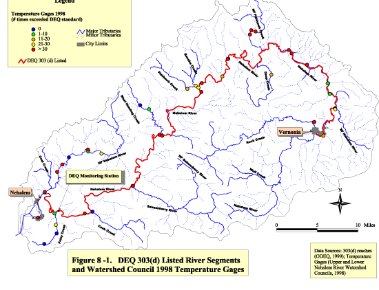
The mainstem Nehalem River from the mouth to Rock Creek is 303(d) listed as water quality limited due to elevated temperature in the summer (See Figure 8-1 and Table 8-2). The upper and lower Nehalem Bay is also listed due to elevated bacteria levels. The bay will not be discussed further as it is being evaluated in another project.
| Figure 8-1
Click image to see full size image. Use you back button to return to this page. |
|
|
Table 8-3 Click image to see full size image. Use you back button to return to this page. |
Table 8-2. Summary of ODEQ Information for the Nehalem River (1998)
Listing Status: 303(d) list
Water Body Segments:Mouth to Rock Creek
Parameter not Meeting Standard:TemperatureSeason: Summer
Supporting Data:USGS and DEQ data; 52% (14 of 27)
Summer values exceeded temperature standard (64° F) with a maximum of 70.7 and exceedances recorded in 1980, 1982, 1984-1993 between water years 1980-1993.
Beneficial Uses Affected: Salmonid spawning/rearing; Resident fish/Aquatic life
DEQ uses a seven-day moving average of the daily maximum to assess temperature. The general standard for temperature is 64° F. This standard was set to protect fish and other aquatic life based on sublethal effects to fish, such as susceptibility to disease, inability to spawn, reduced survival rate of eggs, reduced growth and survival of juveniles, increased competition for limited habitat and food, and reduced ability to compete with other species (GWEB, 1999).
The Upper and Lower Nehalem River Watershed Councils have been monitoring temperature at various locations within the watershed. The 1998 collection sites are shown in
Figure 8-1. There were 48 collection sites with available data including sites on the Mainstem Nehalem River, North Fork Nehalem River, Foley Creek, West Humbug Creek, Fishhawk Creek, and Rock Creek. The temperature was recorded continuously, however the gages were started at various times between May and July, and removed in September and October. The sites were categorized by the number of times the seven-day moving average of the daily maximum temperature exceeded 64 º F. Twenty-seven of the 48 sites recorded more than 30 exceedances of 64ºF. Most of these sites were on the Mainstem Nehalem River, the North Fork Nehalem River, and Fishhawk Creek.
While temperature is the only parameter on DEQ’s 303(d) list, the Oregon Water Quality Index Report for the North Coast Basin for Water Years 1986-1995 reports that water quality for the Nehalem Subbasin becomes impaired in the fall, winter and spring due to elevated levels of nutrients (ammonia, nitrate nitrogen, and total phosphates), biochemical oxygen demand, and total solids. The impairments are attributed to rising water levels during heavy precipitation which may be removing organic materials from fields, banks, and hillsides.
Data from the DEQ monitoring site on the Nehalem River at Foley Road (RM 7.8) gives the only year round water quality data available for the watershed (above the bay). Data available from other sites are generally one time or short-term collections (i.e. data has been collected for one month periods upstream and downstream of carcass placement). Data has been collected by the Nehalem Watershed Councils during 1999, but the data was not available at the time of this printing. The results will be included in the final assessment manual.
The most recent available data from the DEQ site is shown in Table 8-3. Over a year, there were 5 samples collected. Dissolved oxygen, pH, total phosphorus, bacteria, and turbidity levels were in accordance with Oregon Water Quality Standards. There was no data for contaminants such as pesticides, herbicides or metals. Temperature and total nitrate occurred at levels shown to cause impairment to water quality. Temperature exceeded standards in the summer months, while nitrate was high in the fall, winter, and spring.
A plan for water quality improvements are required under the Clean Water Act. DEQ develops Total Maximum Daily Loads (TMDLs) for 303(d) listed waterbodies. TMDLs specify the amount of each pollutant a waterway can receive without violating water quality standards. TMDLs for the Nehalem River Basin have not been established, but are scheduled to be completed in 2001 (ODEQ, 1998). The basin has been given high priority because it supports endangered species (cutthroat trout, steelhead, and coho salmon).
Currently, there are no designated superfund sites within the Nehalem Basin listed with the Environmental Protection Agency.
Data Gaps
There is no comprehensive water quality monitoring program for the Nehalem River and its tributaries. Very little water quality data is available for a watershed of this size. For reliable water quality information and to enable identification of potential sources of pollution, there needs to be a continuous (or frequent), well-distributed monitoring program in the basin. The data collected should meet DEQ monitoring standards including quality assurance protocols.
References
-
Cude, C. 1995. Oregon Water Quality Index Report for North Coast Basin: Water Years 1986-1995. Oregon Department of Environmental Quality, Laboratory Division.
-
Governor’s Watershed Enhancement Board (GWEB). 1999. Draft Oregon Watershed Assessment of Aquatic Resources Manual, January, 1999. Salem, Oregon.
-
Oregon Department of Environmental Quality (ODEQ). 1998. Listing Criteria for Oregon’s 1998 303(d) List of Water Quality Limited Waterbodies. Portland, Oregon.
-
Oregon Department of Environmental Quality (ODEQ). 1998. Oregon’s 1998 Water Quality Status Assessment Report: Section 305(b) Report. Portland, Oregon.
-
Oregon Department of Environmental Quality (ODEQ). 1998. Oregon’s Schedule for Completing Total Maximum Daily Loads for Waters Listed in the 1998 303(d) List. Water Quality Program, Portland, Oregon.
| Maintained by Joseph
Maser |