|
Joseph Maser |
Nehalem
River Watershed Assessment |
Chapters
Contents1.0 Introduction
2.0 Historical Conditions
3.0 Channel Habitat Types
4.0 Hydrology and Water Use
5.0 Riparian Conditions
6.0 Sediment Sources
7.0 Channel Modifications
8.0 Water Quality
9.0 Fish and Fish Habitat
10.0 Watershed Conditions Summary
Home
Projects
PSU
ESR Dept.
The riparian zone is the region along a river, lake or wetland edge that includes characteristic vegetation and animal species which influence stream processes. Riparian areas generally have higher levels of soil moisture than adjacent upland areas. These areas are usually well-vegetated and there are a wide variety of hydrologic, geomorphic, and biotic processes which determine the character of the riparian zone.
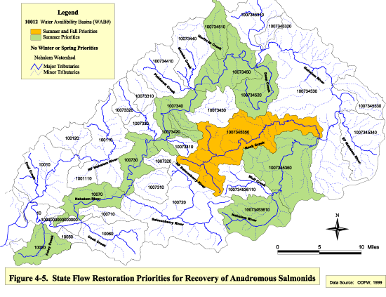
| Figure 4-5 Click image to see full size image. Use you back button to return to this page. |
Fish habitat is influenced by riparian vegetation in many ways. Tree canopy cover shades the streams and keeps the water temperature down and decreases short-term fluctuations in water temperature. Streamside vegetation acts as cover, hiding fish from predators. The root systems in the riparian zone stabilize the banks of the streams, reducing erosion potential. Vegetation also filters sediment from surface flow delivered from upland areas, thereby preventing the sediment from reaching the stream. The streamside vegetation provides habitat to macroinvertebrates which are an important food source for salmonids. It also provides nutrients to the stream by dropping organic material (leaves, branches, needles) into the stream. And, trees which fall into the stream provide important salmonid habitat. The large woody debris provides cover, pools, and and can change shape and flow of the stream, thereby creating more habitat complexity.
Although, all of the functions of the riparian zone are important, they are difficult to quantify and to evaluate each of them is beyond the scope of this assessment. In accordance with the GWEB manual, this assessment evaluates the potential for the riparian zone to provide large woody debris and its ability to provide shade to the basin's streams.
Methodology
This part of the assessment was started using the Draft GWEB Watershed Assessment Manual which was available in July, 1998. Some portions of the January, 1999 edition of the manual are incorporated.
· Riparian vegetation was analyzed using aerial orthophotos. For each bank (left and right, looking downstream), width, continuity and age were determined. The categories were:
Width: Continuity: Age:
A = absent C = continuous Y = young
C = continuous S = some interruptions M = mature
N = narrow (< 30 ft) D = discontinuous G = grass
W = wide (> 30 ft) A = absent U = unknown
· Riparian conditions were categorizes for each reach by assimilating the above parameters into the following conditions:
Good condition: wide riparian zone, mature trees, continuous, fairly continuous or only somewhat interrupted.
Fair condition: narrow riparian zones regardless of age of trees or continuity; or wide riparian zones with discontinuous continuity .
Poor condition: riparian vegetation absent or no trees present in the riparian zone.
· Riparian conditions from the aerial photo analysis were used to determine the future potential for instream large woody debris. The following categories were used:
Good: mature and continuous (with only some interruptions) -or- young, continuous and wide
Moderate: mature and discontinuous –or- young, narrow and continuous
Low: young , narrow and discontinuous or riparian vegetation absent
· The size of the stream and type of vegetation (age and continuity) in the riparian area were factors in determining the shade categories. Where the stream surface was not visible, slightly visible, or visible in patches, a "high" level of shading was assigned. A "moderate" level of shading was assigned where the stream surface was visible but the banks were not. Reaches with little or no riparian vegetation shading the stream were given were put in a "low" category.
Riparian Condition Results (by subwatershed)
Cook Creek
The Cook Creek subwatershed has surprisingly little riparian area in poor condition. The urbanization and farmland in the area are fairly well concentrated around the bay, Foley Creek and the lowest reaches of the mainstem Nehalem River. Reaches with no riparian vegetation are present on Neahkanie Creek, Peterson Creek, Lost Creek and Snark Creek (See Figure 5-1). The riparian zone in this area is typically continuous and greater than 30 feet, with some narrow strips distributed throughout. There appears to be an even distribution of young and mature trees.
Salmonberry
The riparian buffers in the Salmonberry subwatershed are generally in good condition. The left bank of the Salmonberry River, between Buick and Belfort Creeks, is the only riparian area in poor condition. The riparian buffer is generally continuous and greater than 30 feet
wide. The trees are generally young. This area was heavily damaged by the Tillamook Burn in 1933 and again in the Salmonberry Fire in 1945.
Upper Nehalem
The Upper Nehalem subwatershed has two significant reaches with poor riparian conditions. Both Weed Creek and the South Fork Rock Creek have grass on both banks. The rest of the subwatershed typically has continuous riparian buffers with young trees. There are quite a few narrow buffers, mostly on the East Fork Nehalem River, Lower Rock Creek, Beaver Creek, Kist Creek and Lousignont Creek.
Upper Nehalem
The riparian buffer in the Upper Nehalem subwatershed has the most variability in the watershed. There is a concentration of riparian buffer in poor condition along Fishhawk Creek and the North Fork Fishhawk Creek (See Figure 5-1). There are several other small areas along tributaries of the mainstem Nehalem River in poor condition in this area. The subwatershed generally has young riparian trees typical of the entire watershed. About 50% of the buffer strips are less than 30 feet wide and there are widespread interruptions and discontinuities in vegetation along stream banks.
| Figure 5-1 Click image to see full size image. Use you back button to return to this page. |
Lower Nehalem
There is only one small reach at the headwaters of Walker Creek which is in poor condition in the Lower Nehalem subwatershed. Riparian buffers are typically continuous and wide. Most of the buffer along the mainstem Nehalem River and many of the major tributaries in this subwatershed have mature trees.
North Fork Nehalem
The North Fork Nehalem subwatershed has some areas of riparian buffer in poor condition. The headwater areas of Boykin and Rackheap Creeks, all of God's Valley Creek, and
the North Fork Nehalem River between Soapstone Creek and Sweet Home Creek are all in poor condition. The riparian conditions in this subwatershed are generally better on the North Fork Nehalem River and its tributaries above the fish hatchery near the mouth of Sweet Home Creek. Above this point the riparian trees are mostly mature and continuous in wide buffers along the streams. Below the hatchery, buffers are typically continuous but are of mixed ages and widths.
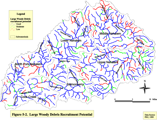
Potential for Large Woody Debris Recruitment
The current levels of large woody debris in the streams of the Nehalem Watershed are discussed in the fish and fish habitat section. Current levels are generally low, especially large pieces of woody material which can significantly increase the quality of fish habitat. Therefore, estimates of the future potential for recruiting large woody debris from the riparian areas is helpful in determining the need for potential restoration projects.
The potential for large woody debris recruitment is low in 13% of the watershed. These are typically streams with narrow, discontinuous strips of young trees along the banks or where vegetation is absent. The lack of recruitable wood is more pronounced in the upper watershed, possibly due to more logging and rural residences (See Figure 5-2). Some of these areas are on small tributaries in the northeast part of the watershed (Eastman, Cedar, Battle, Gus, and North Fork Fishhawk Creeks) and are spawning grounds for coho salmon and sea-run cutthroat trout. These tributaries lack large woody debris recruitment potential and both species require extensive in-stream structure.
Seventy-six percent of the watershed has good potential for recruitment of large woody debris. However, it is important to consider that the majority of the riparian vegetation in the watershed consists of young hardwood species. Generally, the larger the recruitable trees the better they will perform in-stream functions. According to GWEB (1999), stands having a 12 inch average diameter or greater usually provide some amount of recruitable wood. Thirty-two percent of the stream length in the watershed has been surveyed by ODFW (See Figure 9-6 in the fish section). There was not a category describing quantities of trees greater than 12 inches in diameter, however, trees greater than 20 inches in diameter were found in 48% of the 100 ft buffer strips adjacent to streams. Trees greater than 36 inches in diameter were present in 17% of the reaches surveyed.
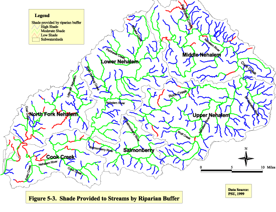
Riparian Shade
Figure 5-3 shows the amount of shade provided to the stream by the riparian buffer. The area near Nehalem Bay has significantly reduced shading of rivers due to urbanization effects. Reaches with riparian buffer which provide low amounts of shade include the Lower Nehalem River to Anderson Creek, the North Fork Nehalem River to Gravel Creek, the lower portion of Coal Creek, and Alder Creek. The amount of shade provided by riparian buffers in the rest of the watershed is largely a factor of stream size. The larger reaches get a moderate amount of shade, while the smaller reaches get a high degree of shade. Exceptions occur where vegetation is lacking due to land use practices.
Oregon Forest Practices Act
The most comprehensive riparian protection rules ever enacted on non-federal land in Oregon went into effect for logging operations on September 1, 1994. These rules will be very important in the Nehalem watershed since all of the forested lands are state or privately owned and the timber is near merchantable age in most areas. The rules require logging operators to leave riparian buffers adjacent to streams which have anadromous fish present during any time of the year. The required buffer varies with stream size:
Stream Size (average annual flow) Required Buffer
Small (<2 CFS) 50 feet
Medium (2-10 CFS) 70 feet
Large (>10 CFS) 100 feet
Operators can vary the width of the riparian buffer below the average specified width due to topography, operational requirements, vegetation, fish and wildlife resources and water quality protection. However, the average width of the entire riparian management area within an operation must equal or exceed the required width (OAR, 1997). Also, operators must expand
the riparian management area as necessary to entirely include any stream-associated wetland of side channel plus at least 25 additional feet.
An additional benefit to the new rules is that they commit the Oregon Department of Forestry (with the help of the Department of Fish and Wildlife) to complete comprehensive fish surveys of forest streams (ODF, 1995).
Data Gaps
· All streams need to be surveyed for riparian conditions including canopy cover, riparian widths, tree species, large woody debris status and shade estimations. Priority should be given to fish bearing streams designated as having poor conditions.
· Agricultural and rangeland practices need to be investigated for use or non-use of buffer strips.
· Presence and distribution of non-native riparian vegetation needs to be investigated.
· There is no GIS coverage of wetlands in the Nehalem watershed.
| Figure
5-2 Click image to see full size image. Use you back button to return to this page. |
|
|
Figure 5-3 Click image to see full size image. Use you back button to return to this page. |
References
-
Oregon Administrative Rules (OAR). 1997. Department of Forestry, Division 635, Water Protection Rules: Purpose, Goals, Classification and Riparian Management Areas. OAR 629-635-0310, Salem, Oregon.
-
Oregon Department of Fish and Wildlife (ODFW). 1999. Habitat and Reach Data Coverages. ODFW Aquatic Inventories Project, Corvallis, Oregon.
-
Oregon Department of Forestry (ODF). 1995. Riparian Protection: Under the Oregon Forest Practices Act. Public Affairs Office, Salem, Oregon.
-
Spencer Gross Aerial Orthophotos. 1995.
| Maintained by Joseph
Maser |