|
Joseph Maser |
Nehalem
River Watershed Assessment |
Chapters
Contents1.0 Introduction
2.0 Historical Conditions
3.0 Channel Habitat Types
4.0 Hydrology and Water Use
5.0 Riparian Conditions
6.0 Sediment Sources
7.0 Channel Modifications
8.0 Water Quality
9.0 Fish and Fish Habitat
10.0 Watershed Conditions Summary
Home
Projects
PSU
ESR Dept.
The focus of this component is to evaluate the impacts of land and water use on the hydrology of the Nehalem Watershed. Hydrologic processes are complicated, however by the kind and extent of land uses present, potential problems can be identified. Land use practices can modify the amount of water available for runoff, the routing of water to the streams, the lag time, the velocity of stream flow, or the travel distance to the stream.
Fish and fish habitat can be impacted by changes in the natural flow regime. High peak flows can alter the characteristics of streams by carrying away large woody debris, moving gravel downstream and eroding streambanks. Low stream flow can limit salmon migration and can expose fish eggs to the air.
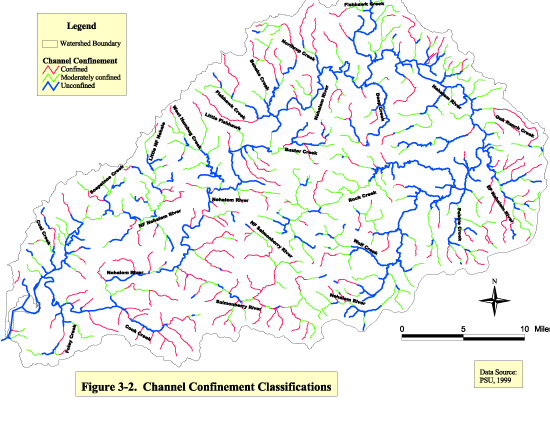
| Figure 3-2 Click image to see full size image. Use you back button to return to this page. |
|
|
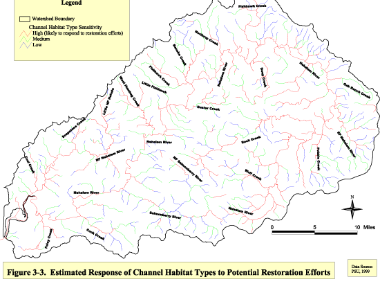
Figure 3-3 Click image to see full size image. Use you back button to return to this page. |
Methodology
For the hydrology section, GWEB guidelines were followed for characterizing peak flows. Precipitation data was collected from US Geological Society and the Oregon Water Resources Department to determine the peak flow generating processes. Then 4 land use categories (forestry, agriculture/rangeland, forest and rural roads, and urban and rural residential development) were evaluated for potential impacts on hydrology. The area comprised of road surfaces in each land use type was calculated by multiplying the linear length of roads by road widths suggested by GWEB (25 feet for forestry roads and 35 feet for rural residential) and then dividing by the area of the land use type.
For the water use section, water rights were summarized using information obtained from the OWRD. Water availability reports for 80% exceedance levels for each month were used to analyze the potential for low stream flows. Flow restoration priority area designations were obtained from ODFW to determine which areas need flow restoration have the opportunity for successful conservation measures.
Hydrology
Watershed Characteristics
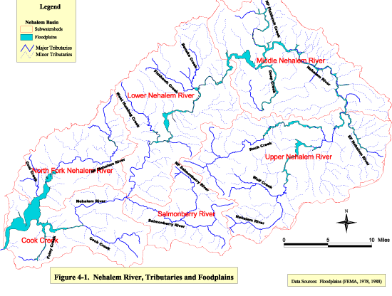
The Nehalem River is one of the longest rivers in Oregon with a length of 118.5 miles. The mainstem Nehalem River’s shape resembles a fish hook as it originates on the east side of the coast range, circles around the northern tip of the mountains and then heads in a southwesterly direction until it drains into Nehalem Bay and then into the Pacific Ocean. The drainage area contains over 935 miles of streams. Major tributaries are Foley Creek, Cook Creek, the Salmonberry River, Humbug Creek, and Rock Creek (See Figure 4-1). The lower Nehalem River above the bay to about River Mile 40 is generally high gradient while the middle and upper river are generally low gradient. The Nehalem River drainage area is approximately 855 square miles with elevations reaching nearly 3,300 feet.
Precipitation
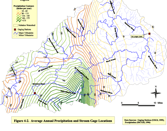
The streams of the Nehalem River drainage are fed primarily by precipitation. Annual rainfall variability exists due to the Coast Range barrier. The mean annual precipitation of the Nehalem Basin is approximately 113 inches. Average annual rainfall, as shown in Figure 4-2, ranges from 95 inches at Nehalem Bay to 200 inches in the higher elevation Salmonberry subwatershed and 55 inches inland in the Middle and Upper Nehalem subwatersheds (SSCGIS, 1996).
Precipitation has been recorded in the watershed since 1938 with some periods of missing data. Tables 4-1 and 4-2 show the variability of monthly mean precipitation and snowfall in the watershed. The average annual precipitation near Nehalem is 121.14 inches for the period 1969-
1998. In Vernonia, the average annual precipitation is 49.05 inches for the period 1967-1998. The highest precipitation occurs between November and March. The driest months are July and August.
|
Table 4-1. Monthly means of precipitation and snowmelt at Nehalem, Oregon for 1969-1998 (inches) |
|||||||||||||
|
|
|
|
|
|
|
|
|
|
|
|
|
|
|
|
Month |
Jan. |
Feb. |
Mar. |
Apr. |
May |
June |
July |
Aug. |
Sept. |
Oct. |
Nov. |
Dec. |
Annual |
|
Precipitation |
18.29 |
14.87 |
12.93 |
8.86 |
5.16 |
3.85 |
2.02 |
1.79 |
5.12 |
9.09 |
18.61 |
20.56 |
121.14 |
|
Snowfall |
1.2 |
0.7 |
0.2 |
0 |
0 |
0 |
0 |
0 |
0 |
0 |
0 |
0.6 |
2.8 |
|
Data Source: Western Regional Climate Center, 1998 |
|
|
|
|
|
|
|||||||
|
|
|
|
|
|
|
|
|
|
|
|
|
|
|
|
Table 4-2. Monthly means of precipitation and snowmelt at Vernonia, Oregon for 1967-1998 (inches) |
|||||||||||||
|
|
|
|
|
|
|
|
|
|
|
|
|
|
|
|
Month |
Jan. |
Feb. |
Mar. |
Apr. |
May |
June |
July |
Aug. |
Sept. |
Oct. |
Nov. |
Dec. |
Annual |
|
Precipitation |
7.45 |
5.63 |
5.16 |
3.75 |
2.32 |
1.66 |
0.61 |
0.84 |
2.12 |
3.99 |
7.19 |
8.33 |
49.05 |
|
Snowfall |
4.3 |
3.2 |
0.4 |
0 |
0 |
0 |
0 |
0 |
0 |
0 |
1.1 |
2.4 |
11.4 |
|
Data Source: Western Regional Climate Center, 1998 |
|
|
|
|
|
|
|||||||
The Oregon Coast Range mountains are at low elevations and do not collect snow that supplements spring and summer flows. Snow that accumulates is quickly washed away by winter rains. Rain-on-snow events that significantly affect peak flow levels occur only rarely, as in the February, 1996 flood. The Natural Resources Conservation Service maintains a SNOTEL site on Saddle Mountain, elevation 3,250 feet, which is just northwest of the watershed. Measurements at this site can be used to give an approximation of snow levels at the highest elevations in the Nehalem River watershed.
The February 6-9, 1996 storm produced the the peak of record (greater than a 200-year recurrence interval) at the Nehalem River near Foss gaging station. A contributing factor to the peak magnitudes of the February 1996 floods was the snowmelt that occurred from snow that covered even low elevations of the Oregon Coast Range. The NRCS recorded a snow-water equivalent loss of 14 inches at the SNOTEL site on Saddle Mountain (Taylor, 1997). The storm produced the highest 4-day precipitation event on record. At the Nehalem gaging station, the event totaled 19.8 inches of rainfall. In Vernonia, 8.18 inches of rainfall was recorded over the 4-day period (USGS, 1999). Information on these extreme events is of interest because they can change the shape of the stream channel and can impact the floodplains.
Stream flow
The U.S. Geological Survey (USGS) and the Oregon Department of Water Resources (OWRD) have maintained stream flow gage stations in the Nehalem River watershed since 1939. A gauging station on Fishhawk Creek near Jewell (#14300400) was operated from 1970 to 1976. It’s drainage area was only 0.71 square mile. A gage station was operated on Oak Ranch Creek near Vernonia (#14300200) from 1958 to 1969 which had a drainage area of 11.6 square miles.
The gage station on the Nehalem River near Foss (#14301000) has been in continuous operation since 1939. This gage station records daily discharges for the Nehalem River at RM 13.5. It is 32.5 feet above sea level and the drainage area above the gage is 667 square miles.
| Figure
4-1 Click image to see full size image. Use you back button to return to this page. |
|
|
Figure 4-2 Click image to see full size image. Use you back button to return to this page. |
Average discharge during the 59 years of operation is 2,672 Cubic Feet per Second (CFS) or 1,936,000 acre-ft per year. Maximum discharge was 70,300 CFS on February 8, 1996 and minimum discharge was 34 CFS during the period August 29-31, 1967. Average peak flow is 28,776 (Figure 4-3).
Daily discharge in CFS for the 1998 water year are shown in Table 4-3. According to the Oregon Water Resources Department (1999), 85% of the total discharge in the watershed occurs between November and April. During the 1998 water year, the maximum daily discharge was 22,800 CFS on October 30, and the minimum daily discharge was 83 CFS on September 17.
|
Table 4-3 Use you back button to return to this page. |
Land Use
Land uses have a potential impact on the hydrology of a watershed. The amount of water available for runoff, the lag time (delay between a precipitation event and peak streamflow), the flow velocity, and the travel distance of precipitation to the stream are potential alterations related to land use practices (GWEB, 1999). Table 4-4 shows the land use practices existing in
the Nehalem River watershed. The “Other” category includes natural resources, parks and recreation, rural industry, and rural residential.
|
Table 4-4. Approximate Proportion of Land Use Type by Subwatershed |
|
||||
|
Subwatershed |
Forestry |
Ag/Rangeland |
Ag/Rangeland/Forestry |
Urban |
Other |
|
Cook Creek |
87.2% |
3.8% |
2.5% |
2.3% |
4.2% |
|
Salmonberry River |
100% |
-- |
-- |
-- |
-- |
|
Lower Nehalem River |
90.7% |
1.6% |
4.9% |
-- |
2.8% |
|
North Fork Nehalem River |
84.6% |
3.9% |
0.9% |
-- |
2.5% |
|
Middle Nehalem River |
95.8% |
0.7% |
2.7% |
-- |
0.8% |
|
Upper Nehalem River |
95.1% |
-- |
3.0% |
0.7% |
1.2% |
|
Entire Watershed |
92.2% |
1.7% |
3.7% |
0.5% |
1.9% |
Data Source: SSCGIS, 1996
Forestry
The watershed is primarily used for timber harvest. Forestry practices impact hydrology in a watershed by removing and disturbing vegetation and by building associated road networks. Decreased canopy cover allows precipitation to reach the soil surface faster thereby increasing runoff and peakflow (Maidment, 1993). Compacted timber roads prevent infiltration of rainfall into the soil and channel runoff directly to streams. Table 4-3 shows forest road densities present in the watershed. The calculated road lengths in the watershed are an underestimate as the best GIS coverage available for streets is 1:100,000 scale. According to the GWEB manual (1999), watersheds where roads occupy <5% of the basin show that peak flow changes due to roads are small, inconsistent, and statistically insignificant. Streams in the Nehalem River basin tend to be flashy. Streamflow levels rise quickly and subside just as fast as the rain event passes. The decreased infiltration during the wet seasons also impact the streamflow during the dry season by inhibiting groundwater recharge (Maidment, 1993).
|
Table 4-3. Forest Road Area Summary |
||
|
Subwatershed |
Total Linear Distance |
Percent of Forested |
|
|
of Forest Roads |
Area in Roads |
|
Cook Creek |
273.08 |
1.32% |
|
Salmonberry River |
170.04 |
1.12% |
|
Lower Nehalem River |
344.04 |
0.98% |
|
North Fork Nehalem River |
264.68 |
1.38% |
|
Middle Fork Nehalem River |
401.34 |
1.10% |
|
Upper Nehalem River |
443.1 |
0.93% |
|
Entire Watershed |
1896.28 |
1.14% |
Data Source: NOAA, 1996
Rain-on-snow events present the greatest likelihood of causing peak flow problems from timber harvest (GWEB, 1999). Since snowpack rarely occurs in the watershed and forest road density is small, the potential risk of peak flow enhancement associated with timber harvest is low.
Agriculture
Approximately 2% of the watershed area is in agricultural/ rangeland use. The primary use (98%) is livestock grazing. Rangeland in the watershed has approximately 50-75% groundcover (grasses) and has a moderate amount of grazing (Mallory, 1999). Grazing animals impact hydrology by removal of vegetation and compacting of the soil surface. In general, moderate grazing reduces the capacity of the soil to soak up rainfall to 75% of the ungrazed condition (GWEB, 1999). This increases surface flow and decreases groundwater recharge. A small percentage (2%) of agricultural land is used to grow crops such as poplar orchards and artichokes (Mallory, 1999). Overall, agriculture has a low risk potential of enhancing peak flow in the watershed due to the small percentage of area.
Rural Roads
Roads associated with rangelands comprise approximately 3.2% of the total rangeland area of the watershed. The Cook Creek and Lower Nehalem River subwatersheds have the highest rural road densities of 5.04% and 4.6% respectively. Rural road densities between 4% and 8% have a moderate risk potential of enhancing peak flow (GWEB, 1999). See Table 4-4.
|
Table 4-4. Rural Road Area Summary |
|
|
|
|
Subwatershed |
Total Linear Distance |
Percent Area |
Relative Potential |
|
|
of Rural Roads (miles) |
in Roads |
for Peak Flow Enhancement |
|
Cook Creek |
42.72 |
5.04% |
moderate |
|
Salmonberry River |
-- |
-- |
low |
|
Lower Nehalem River |
50.5 |
4.60% |
moderate |
|
North Fork Nehalem River |
22.68 |
3.06% |
low |
|
Middle Nehalem River |
18.89 |
3.42% |
low |
|
Upper Nehalem River |
16.07 |
3.16% |
low |
|
Entire Watershed |
150.86 |
3.20% |
low/moderate |
Data Source: NOAA, 1996
| Figure
4-3 Click image to see full size image. Use you back button to return to this page. |
Urban areas in the watershed are extremely small and occur at Nehalem, Wheeler, Mohler, Birkenfeld and other rural residential enclaves. Potential impacts from urban areas consist of impervious surfaces (concrete, rooftops, etc.), stormwater runoff, chemical pollution and as sediment sources during construction activities. The small percentage of urban area currently in the watershed has low potential of peak flow enhancement problems.
Water Use
Diversion of water from streams for irrigation, drinking water or other purposes can potentially reduce stream flows to levels that change water quality and aquatic ecosystems. The locations and types of potential impacts associated with water use are described in this section.
Water Rights
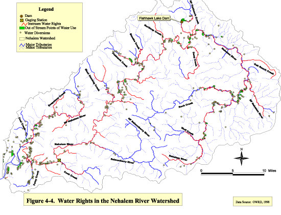
Any person or entity withdrawing water from a stream or groundwater source, must obtain a water right from OWRD. Each water right certificate specifies a maximum rate at which water can be withdrawn, an annual volume restriction and a designated beneficial use without waste. The earliest water rights in the watershed date back to 1911, on the Salmonberry River, Bobs Creek and Fall Creek. There are 542 water rights, including surface water, groundwater, and reservoirs, on record with OWRD for the Nehalem River basin with a potential diversion of 93.25 CFS (OWRD, 1999). Figure 4-4 shows water rights permit locations in the watershed. Some rights are used concurrently and amounts vary by season.
OWRD (1999) water rights for the Nehalem River watershed list 20 beneficial use codes. The quantities of water rights in each beneficial use category for the Nehalem watershed are: fish (33.3%), irrigation (25.8%), municipal (14.1%), geothermal manufacturing (8.8%), domestic (7.5%), fire protection (4.6%), and an “other” category (livestock, agriculture, recreation, wildlife, campground, dairy barn, and power).
There is an earth dam on Fishhawk Creek which forms Fishhawk Lake. The dam is privately owned by Fishhawk Lake Recreation Club, Inc. and holds 982 AFT for recreational purposes. It is 420 feet in length and 35 feet high with maximum discharge of 2500 CFS. The drainage area above the dam is 18 square miles. OWRD (1999) classifies the dam as a significant hazard to property, with possible indirect loss of life (i.e. auto wreck due to washed out bridge) in the event of a sudden failure of the dam. The hazard rating is not a reflection on the physical condition of the dam (Falk, 1999).
There are many small reservoirs and off-channel ponds scattered throughout the watershed. Total storage of water is 1273.57 Acre Feet. According to OWRD, uses of stored water in the watershed include: recreation (77.5%), fish (15.4%), wildlife (5.2%), irrigation (1.4%), and an “other” category (fire protection, livestock, domestic/non-commercial). There are no large-scale means of supplementing summer low flows for aquatic life in the Nehalem River watershed.
Multiple small municipal water supply diversions occur near the urban areas bordering Nehalem Bay. Additional diversions occur for Vernonia, Timber, and Keasey. The largest municipal diversion is from a well at Peterson Creek which is allowed 3.6 CFS.
In order to maintain flow to the most senior water rights holders and to prevent over-allocation of water, OWRD manages water rights according to the principle of “prior appropriation”. This means that the more senior the water right, the longer water is available to that permit holder in a time of shortage. Permit holders that have a more recent priority date are required to forfeit their allotted quantity of water diversion until stream flow levels increase (OWRD, 1999).
Instream water rights were established in 1987 to maintain flow levels in streams for fish protection. These rights have a priority date and are regulated in the same way as other water rights. The oldest and largest instream water right is for converted minimum flow on the mainstem Nehalem River at RM 11. The priority date is 1962. At that time water rights were given for a specific point. Later, instream water rights were established for entire reaches. Instream water rights have been established for the entire mainstem Nehalem River and for many major tributaries (See Fig. 4-4). The minimum flow for July-October is 100 CFS for the point at RM 11 on the Nehalem River. Minimum flow was not being met 20% of the time in August and 37% of the time during September for the period 1980-1992 (ODFW, 1993).
Water Availability
Water withdrawals reduce stream flows which may have an adverse effect on salmonids. Low summer flows have the most significant negative impact due to water levels insufficient for fish mobility and increased water temperatures. Water rights may substantially reduce flows during the summer. If enough senior rights holders used their full entitlement, some streams could be completely dewatered. Most instream water rights in the Nehalem River watershed have a much newer priority date than most of the significant out-of-stream rights.
Estimates of water availability at the 80% exceedence level (streamflow that is present in the river 80% of the time over a 30 year period) were used to determine the potential low flow problems. Many potential water deficits were identified throughout the watershed. OWRD has identified 37 Water Availability Basins (WABs) for the entire watershed. These represent basins associated with tributaries of the Nehalem River. There are 37 WABs in the Nehalem River basin and at some point during the year, each of them has a potential water deficit. Additional water rights may still be issued on a seasonal basis, when and where there is not a potential deficit (Beaman, 1999).
Stream flow Restoration Priorities
ODFW and OWRD collaborated to develop the Streamflow Restoration Priority Areas as an outcome of the Coastal Salmon Restoration Initiative. Priority areas were identified based on a combination of biological factors and water use. ODFW identified priority areas where flow enhancement to support fish populations was needed. OWRD identified areas in which
| Figure
4-4 Click image to see full size image. Use you back button to return to this page. |
opportunity existed to enhance in-channel flows. A priority was established based on the combination of factors identified. No WABs were given priority in winter or spring for the
Nehalem River watershed. However, fall priority was given to the WAB containing Rock Creek and summer priority was given to Rock Creek as well as many of the WABs along the mainstem Nehalem River (See Figure 4-5).
OWRD and ODFW have developed strategies for restoring the priority areas which include: canceling unused water rights, instream leases and transfers, enforcement and monitoring of existing water rights, alternative diversion sites and methods that reduce impact on streamflow, conservation planning and improved efficiency planning (Parrow, 1999).
Data Gaps
1. Information on the degree of water actually being used by water rights permit holders is needed.
2. The extent of illegal water diversions should be researched.
3. Snow accumulation data in the highest elevations is not available.
4. Information regarding the specific crop rotations in the Nehalem Watershed is needed, including water needs and estimated return flows.
5. Information is needed regarding livestock operations, including animal populations and management practices.
References
-
Beaman, G. August 23, 1999. Personal Communication. Watermaster, Oregon Water Resources Department, Tillamook Office.
-
Falk, J. 1999. Personal Communication. Oregon Department of Water Resources, Salem, Oregon.
-
Governor’s Watershed Enhancement Board (GWEB). 1999. Oregon Watershed Assessment of Aquatic Resources Draft Manual.
-
Maidment, D.R. 1993. Handbook of Hydrology. McGraw-Hill, New York.
-
Mallory, E. August 18, 1999. Personal Communication. Tillamook Soil and Water Conservation District.
-
National Oceanic and Atmospheric Administration (NOAA). 1996. Shapefile: Streets.shp.
-
Oregon Climate Service (OCS). 1997. Water Year Precipitation. Internet at: http://www.ocs.orst.edu/pub_ftp/climate_data/divisions/
-
Oregon Department of Fish and Wildlife (ODFW). 1993. Nehalem Basin Forest Land Habitat Issues.
-
Oregon Department of Fish and Wildlife. 1999. Shapefile: Flow Restoration Priorities for Recovery of Anadromous Salmonids in Coastal Basins.
-
Oregon Water Resources Department (OWRD). 1997. Water Rights in Oregon: An Introduction to Oregon’s Water Law and Water Rights System.
-
Oregon Water Resources Department. 1999. Summary of Water Rights Quantities for the Nehalem River and it’s Tributaries. Internet at: ftp://snake.wrd.state.or.us
-
Oregon Water Resources Department. 1999. Dam Information. Internet at:
-
http://www.wrd.state.or.us/cgi-bin/dam_detail.
-
Oregon Water Resources Department (OWRD). 1999. Detailed Report on Water Availability.Internet at: ftp://ftp.wrd.state.or.us/pub/wars/
-
Parrow, D. 1999. Streamflow Priority Areas: Determining the Likelihood for Streamflow Enhancement. Oregon Water Resources Department.
-
State Service Center for GIS (SSCGIS). 1996. Shapefile: Average Precipitation for the State of Oregon from 1980 to 1990, provided by USGS.
-
Taylor, G. 1997. Causes of the Great Flood of 1996 and a Comparison to other Climate Events, Proceedings of the Pacific Northwest Floods of 1996 Water Issued Conference
-
United States Department of Commerce. 1973. Precipitation-Frequency Atlas of the Western United States, NOAA Atlas 2, Vol. X-Oregon.
-
United States Geological Survey (USGS). 1999. Peak Flow Data. Internet at: http://waterdata.usgs.gov/nwis-w/OR/data
-
Weber, W. and Knispel, W. 1977. Final Report: Anadromous Fish Conservation Project, United States Fish and Wildlife Service, Portland, OR.
Western Regional Climate Center (WRCC). 1998. Period of Record General Climate Summary. Internet at: http://www.wrcc.dri.edu/cgi-bin/cliGCStP.pl?or
| Maintained by Joseph
Maser |