For more years than I can remember, I've been going on a (nearly) annual back-packing trip with my brother, who conveniently lives in eastern Washington, within a reasonable drive of several pretty wild places. For the past several years we've been going out for well over a week, often 10 -14 days, a length of time that allows us to reach much more remote areas, and also affords the opportunity to forget or at least disregard the passage of normal, bureaucratic time. This year, Dean's son John was interested in joining us, making it a threesome. For various reasons, we decided to schedule it for the last two weeks in August. John and I drove over to Pullman in John's VW van, transferred our packs into Dean's SUV, and we all motored on over to Lowell, where we had reserved a room at Three Rivers Lodge (our favorite jumping-off place). There, we had a steak and beer, watched the wild turkeys in the campground until dark, and went to bed.
Recently we've been going into the Selway-Bitterroot wilderness area, which straddles the Idaho-Montana border between Missoula and Lewiston. It's a huge area, and anyone willing to hike 15 miles or more (with an elevation gain of about 4000 feet) can easily spend a week or longer with no human contact, other than one's own party. This year we decided to go in at Wilderness Gateway, 30 miles or so up the Lochsa River from Lowell, and hike up Boulder Creek, then on up onto the main ridge between the Lochsa and Moose Creek drainages, and follow that ridgeline, more or less, into the rugged, broken peaks known as the Crags. We've been exploring that area for some time, sometimes entering from Wilderness Gateway, and going in to Lone Lakes, and sometimes from Fog Saddle, going in to North Three Links Lakes. We were pretty sure we had a route figured out that would allow us to pass from North Three Links Lakes to Lone Lakes, and thus close a loop that might or might not include descent into Old Man Meadow. To the extent that this trip had an "objective" (other than pure escapism) that was it.
In the past, we've carried all our groceries on our backs, a load that, along with tents, clothes, a couple of books to read during the rained-in periods, etc. adds up to 75- 80 pounds each. This time we decided to hire an outfitter to take a week's groceries in for us, and meet us on top of an extension of the main ridge, at Lottie Lake. That worked out pretty well, allowing us to climb the 4000 feet up to the ridge with less than 60 pounds in each of our packs, and we'll probably do it again when our route is such that it works out.
Sunday, August 18: We delivered the bulk of our food to the outfitter at about 8 and were on the trail before 9. It was a beautiful, mild day, temperature in the 70s even in mid-afternoon. We reached the crossing over Boulder Creek by mid-afternoon. John and I both took a bath in the creek (it's cold enough that a bath consists of a quick rinse, but it feels really great), then we gathered huckleberries (the woods were full of them, and we managed to pick close to three quarts in a fairly short time). After dinner, Dean invented an interesting dessert: He put some fig newtons in the bottom of a cereal bowl for each of us, added some chopped up walnuts, then poured a syrup made by boiling huckleberries with brown sugar and a little water (enough to keep the pan from burning) over them. It was delicious! The next morning, we had huckleberry pancakes; we also took enough huckleberries with us to have another meal of pancakes.
On Monday morning, we broke camp, packed up and hit the trail by around 8, walked up Surprise Creek to the Cliff Creek trail, then headed up Cliff Creek. We had thought of going all the way up Surprise Creek, but we were told that a trail crew was working up that way (and we heard dynamite blasts a couple of times). The trail up Cliff Creek is in fairly good shape, although it is still pretty steep in spots - by the flags tied here and there, I gather they plan to re-do parts of the trail to reduce the grade. We didn't make as good time as expected, so we didn't reach the top of Cliff Creek and the junction with the main ridge trail until a little after noon. We stopped in a sloping little meadow near the junction, with a view out over the mountains to the south, to eat our lunch.
While we were eating lunch, we noticed a column of smoke coming up over
a ridge that appeared to be something like ten miles away. We looked
for it every time we stopped for rest in an open spot, checked our maps,
and concluded that it was coming from the ridge between Wounded Doe Ridge
and East Fork of Moose Creek. Moose Creek canyon was filled with
smoke, and we also saw several other smaller columns of smoke on various
other ridges. John and I were somewhat sensitized by the raging fires
in Southern Oregon. The woods we were hiking through were pretty
damp, compared to those in the Southern Oregon fire, and the wind was actually
blowing from us toward the fire, but it still had us somewhat concerned.
However, none of the smoke columns seemed to be growing or moving, so we
decided not to worry too much about it. In any event, there wasn't
much we could do about it until the next day.
We reached our planned campsite again around mid-afternoon, and discovered
to our dismay that the spring from which we usually get water was nearly
dry. There was no more than a very small trickle - barely enough
to get water to filter. As soon as we were certain the water was
actually running (not stagnant) we decided it would be okay to go ahead
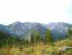
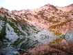
and use it, after filtering. I love that particular campsite:
As you can see from the photo, the view from the campsite is spectacular.
The area to which we planned to hike is along the skyline near the center
of the picture, beyond the ridge that projects directly toward the campsite
itself. 
The next morning, Tuesday, the smoke columns were still visible on
the horizon, but most of the smoke had cleared away from Moose Creek Canyon,
so we concluded that fire was not an imminent danger. We emptied
our packs except for lunch, water, and something to read, and headed over
to Lottie Lake to meet the horse packer with the rest of our food.
It was a very pleasant walk; once again the weather was all but sublime.
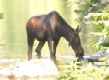
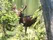
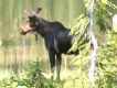
We met a couple of day hikers who were camping at one of the lakes; they
told us there were three moose in Mud Lake, so we detoured slightly off
the trail to see them. 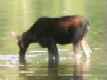 It
turned out there were five, including two males. (None of the pictures
on this page is over 51kb; most are in the range of 25-35kb.)
It
turned out there were five, including two males. (None of the pictures
on this page is over 51kb; most are in the range of 25-35kb.)
We had a pleasant morning at Lottie Lake. Dean took a sponge
bath and John and I found places where we could actually get in for a refreshing
swim. The lake is shallow along most of the shore, and lined with
mud and wild rice, but we managed to find some rocks that sloped into water
deep enough to get in and out without stirring up too much mud. The
horse packer arrived at about 1:30, a half hour before the appointed time.
We transferred the groceries into our packs, and hiked back to our camp
site, arriving well before 5, after about a three hour walk. In the
evening after dinner, it clouded up and rained a little, so we went to
bed with rain flies down. 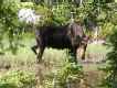
Wednesday morning it was clear and nice when we got up. I made
bread for lunch but it was too cold to rise, so we decided to take it along
and cook it at Lone Lake when we arrived. By the time we left camp,
fog was rolling over us in thick banks and the sun was almost entirely
obscured. The trail over to Lone lakes goes along the ridgeline,
passing around a few rockpiles and over more of them. It was eerie
hiking along the ridgeline through the fog; occasionally we would get a
brief glimpse down into the valley, 500 to 1000 feet below, then the fog
would close back in.
When we reached North Lone lake, we found a fairly attractive camp site, but since we intended to look for a route up over the ridge, we hiked on over to South Lone Lake to see if there might be a camp site there. We didn't find a very good one, so hiked back over to the first camp site. I fired up the little coffee can stove I made; it took about a half hour to bake the bread. In spite of not having risen at all before hand, it rose enough while I was baking it to be surprisingly good. While I did that, John gathered some firewood. We barely got camp set up and a tarp pulled over our packs and the stacked up firewood when it started raining. Dean retreated into his little tent, and John and I into our slightly larger tent, with books, canteens, and a few snacks.
I had brought along a little contraption that turns a sleeping pad into
a legless chair, so I rigged it up in the tent. It works marvelously
well, although after a couple hours of reading and listening to the rain
on the tent, I began to feel a bit of cabin fever. It was also getting
late enough in the afternoon that I realized we were going to have to start
thinking about dinner. So I put my rain clothes back on and climbed
out of the tent. The rain had eased up, and by the time John and
Dean had also climbed out, it stopped. It had rained quite hard for
a while, and our tent was in a pool of water over an inch deep, as deep
as three inches in some places; there were several other pools of like
depth, including one that covered the fire ring area.  The
ground had been so dry that the rain apparently did not soak in at all.
We messed around, draining the pools from around our tents for awhile -
eventually the water soaked through the hard-packed surface soil and the
pools drained by themselves. I used the coffee can stove, set up
on a rock above the wet ground, to bring water close enough to a boil to
cook some minute rice and freeze-dried peas for dinner, then to heat some
water to do dishes. John and Dean did dishes standing up because
the ground was all soaking wet. By the time we finished dinner and
cleaning up it was getting quite cold, so we went to bed as soon as it
started getting dark, at about 8:00.
The
ground had been so dry that the rain apparently did not soak in at all.
We messed around, draining the pools from around our tents for awhile -
eventually the water soaked through the hard-packed surface soil and the
pools drained by themselves. I used the coffee can stove, set up
on a rock above the wet ground, to bring water close enough to a boil to
cook some minute rice and freeze-dried peas for dinner, then to heat some
water to do dishes. John and Dean did dishes standing up because
the ground was all soaking wet. By the time we finished dinner and
cleaning up it was getting quite cold, so we went to bed as soon as it
started getting dark, at about 8:00.
Having gone to bed so early, I awoke as soon as it started getting light, at about 5:10. We had come pretty well equipped for wet weather, and no-one seemed inclined to call retreat. I used the coffee can stove to heat water for coffee while Dean and John went out and found a fallen, half-rotton log they were able to roll over, to get the drier wood from the bottom. By the time they got back, I had coffee ready. The makeshift stove worked great for baking bread, and it would heat water fairly well, but the pans didn't make good contact with the top, so it would not bring water clear to a boil, and it was too slow for cooking pancakes. But with the wood Dean and John brought back in, we were able to get a campfire going; soon we were eating pancakes and sipping coffee, and the world looked a lot better.
We've debated the merits of cooking on a campfire versus a gasoline stove, and on shorter trips usually use the stove. But we've found that it isn't easy to carry enough gasoline for things like frying bread, so we've gone back to using the campfire. If I can get the coffee can stove perfected, we may start doing a combination, using the coffee can stove for the long, slow cooking chores like frying bread, the gasoline stove for bringing water to a quick boil, and for cooking when everything is wet. The coffee can stove works well, and would be great if I could work out a more efficient heat transfer: In effect it is a self-contained chimney, and will get fairly hot with only a few twigs. It will also burn half-wet twigs. Made of a gallon tin can, it weighs only a couple of ounces and takes little extra space. They key is to get big enough holes at top and bottom to move air through efficiently.
A word about fried bread. We've tried several ways to have bread for lunch; we've had the best luck with a recipe adapted from one my mother used to make. Whenever she'd make yeast bread, she would save out some of the dough, pat it out thin, and fry it. So we combine flour, yeast, a little sugar to feed the yeast. On the trail we add enough water to make it workable, knead it, let it rise for an hour or so, knead it again and flatten it as much as possible, then let it rise for another hour or so and fry it, ten minutes on each side, in just enough oil to prevent sticking to the pan. On a cooler day, it helps to put a blackened pan over the dough to concentrate what little head there is from the sun. If it's too cool to rise at all, we cook it slower, and it will rise enough while it is cooking that it isn't too hard or tough.
After we cleaned up we buttoned up camp to be watertight in case of more rain, and set out to find a way over the saddle to East Peak Lake, and on down into upper Three Links Creek valley below. We found what looked like an old mule trail up to the saddle, and an easy way down to the narrow little bench above East Peak Lake. The route from there wasn't clear: It looked brushy down toward the lake, but from the topo map it appeared that the way down into the next valley would be steeper from the end of the bench above the lake. On the other hand, if we started from the lake, the way down would be less steep but would lead us much deeper into the valley than we wanted or needed to go, and it looked like the valley floor would be pretty thick with alder and other brush. But in any event, it looked pretty good for getting down to the valley. It was a nice day hike, although it was cloudy and cool most of the day, and we were still somewhat worried about more rain.
The next day, Friday, the weather turned for the better. We had a beautiful day, with no clouds until late afternoon. That weather pattern held throughout most of the rest of the trip: Clear most of the day, then clouding up in the late afternoon, sometimes leading to a thunderstorm and rain, sometimes not. We hiked over the pass, and found a route down to East Peak Lake. Unfortunately, we did not find any really good camp sites. There was a broad meadow where it looked from above that we could camp, but when we got there the grass was very deep, the ground wet and marshy, and the air filled with mosquitoes, gnats, and deer flies. We went on, and found a serviceable spot on a little rise above the lake, with flat spots for our tents, and a rocky area where I was able to build a passable fire ring to cook.
The lake had one very desirable feature, after three days without a bath: A big rock ending in a slab that slants out into water that is over six feet deep. It was a great place to jump in and swim around and wash off most of the dust, smoke, and sweat of three days. It felt great!
 Saturday
morning, we put on our packs and hiked out to the beginning of the slope
down into upper Three Links Valley. After exploring a bit, we found
an old mule track leading across the face of the slope, to the top of a
gentler rock-strewn slope leading down into the valley. From the
top of that rocky slope, it looked pretty promising for climbing back up
to the bench above the lake, and by-passing the lake entirely on the way
back.
Saturday
morning, we put on our packs and hiked out to the beginning of the slope
down into upper Three Links Valley. After exploring a bit, we found
an old mule track leading across the face of the slope, to the top of a
gentler rock-strewn slope leading down into the valley. From the
top of that rocky slope, it looked pretty promising for climbing back up
to the bench above the lake, and by-passing the lake entirely on the way
back.
Before we went on down to the creek we paused to eat a granola bar and
inspect the hillside on the other side: Somehow, we needed to get
our packs up to the ridge so we could carry them on over to North Three
Links Lakes. 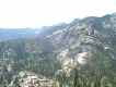 Dean
and I had already tried two routes, and didn't much like either. The first
was right down the end of the ridge - it looks good on the topo map, but
as it turns out there is a series of six to ten foot cliffs that we had
to work our way around, either through thick brush or across precarious
scree slopes. The other was up a dry creek bed, large blocks of tumbled
rock; passable but not much fun, and a bit treacherous carrying packs.
We'd been told there is a mule track leading up the valley but didn't have
any details.
Dean
and I had already tried two routes, and didn't much like either. The first
was right down the end of the ridge - it looks good on the topo map, but
as it turns out there is a series of six to ten foot cliffs that we had
to work our way around, either through thick brush or across precarious
scree slopes. The other was up a dry creek bed, large blocks of tumbled
rock; passable but not much fun, and a bit treacherous carrying packs.
We'd been told there is a mule track leading up the valley but didn't have
any details.
When we reached the base of the mountain, the valley below the rocky
slope seemed quite thick with brush and scrubby little trees. 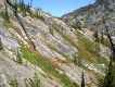 We
saw what appeared to be a pretty straightforward route, going slant-wise
across the face of the slope, so we decided to give it a try.
We
saw what appeared to be a pretty straightforward route, going slant-wise
across the face of the slope, so we decided to give it a try. 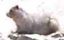 About
a third of the way up it, we realized that it was steeper than it looked,
and we had to stop several times, take off our packs, and check out alternative
ways forward. It was actually quite a bit of fun, but it would have
been more fun without sixty pound packs on our backs! One of the
benefits was that we spotted a large animal sunning itself on a rock, halfway
up. At first we thought it was a carnivore of some sort, but when
we looked it up on various web pages after we got home we discovered it
was almost certainly a hoary marmot. In any event, it was a beautiful
creature, and fun to see. On the way back, when we saw the slope
from above, we couldn't believe we had actually carried packs up it!
For all that, it was a fun hike up.
About
a third of the way up it, we realized that it was steeper than it looked,
and we had to stop several times, take off our packs, and check out alternative
ways forward. It was actually quite a bit of fun, but it would have
been more fun without sixty pound packs on our backs! One of the
benefits was that we spotted a large animal sunning itself on a rock, halfway
up. At first we thought it was a carnivore of some sort, but when
we looked it up on various web pages after we got home we discovered it
was almost certainly a hoary marmot. In any event, it was a beautiful
creature, and fun to see. On the way back, when we saw the slope
from above, we couldn't believe we had actually carried packs up it!
For all that, it was a fun hike up. 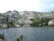
The hike on into North Three Links Lakes was relatively straightforward.
Once again, we reached our camp site on the uppermost of the three lakes
around mid-afternoon, early enough to get some bread made and take a swim
in the lake before dinner time. After dinner, we enjoyed watching
a little water-bird chasing bugs along the water's edge. It had a
pleasant little song - There wre two or three of them, and I think they
use the song to keep track of each other. We watched a rather heart-breaking
little drama. A moth apparently got too close to the water and got
its wings wet. It kept fluttering spasmodically, attempting to free
itself. It did that periodically for over a half hour, as the breeze
gradually blew it across the lake. When it got close enough to our
shore for us to be sure what it was, the little water bird saw it, made
a quick dive, and the moth's struggles were over. 
Sunday morning our plan was to hike up to the ridge above the lake
and see whether we could find a way down into the valley below that we
trusted well enough to try it with packs on. When we got up, it was
a very nice morning: Sunrise, reflecting on the ridge behind the
lake, was beautiful. Dean and I sat on the rock where we liked to
eat our meals, above the water at the edge of the lake, and finished our
last cup of coffee while John climbed up the rocky hill to try to get a
picture of the lake without anything in front of the camera; while he was
at it, he snapped a couple of pictures of us.
The climb up to the ridge was pretty easy. The first place we
reached, the slope below was covered with huge fallen rocks. We worked
our way down the rockfall; it wasn't too bad, although it's always more
difficult to carry packs over those blocks of rock than over smaller stuff.
There were some fairly large cliffs to work our way down around.
Partway down I got out onto a large rock where I could see the slope to
our right, and it appeared that there was a long slope with no cliffs or
other obstacles a couple hundred yards north of us. We worked our
way over there, then worked our way on down. 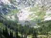 We
had set a limit of 11:00 a.m. as a turnaround time; by 10:30 it was clear
we would not succeed in finding a workable route to the valley floor and
have enough time left to cross the valley and check out the exit into Old
Man Creek valley. So we decided to look for that route from the lower
end next time we're up here, and turned back. The route back upslope
to the ridge top was steep but not difficult; I wouldn't have any hesitation
carrying a pack up it. We also had a really nice, clear
view down toward Florence Lake, at the very top of the valley.
We
had set a limit of 11:00 a.m. as a turnaround time; by 10:30 it was clear
we would not succeed in finding a workable route to the valley floor and
have enough time left to cross the valley and check out the exit into Old
Man Creek valley. So we decided to look for that route from the lower
end next time we're up here, and turned back. The route back upslope
to the ridge top was steep but not difficult; I wouldn't have any hesitation
carrying a pack up it. We also had a really nice, clear
view down toward Florence Lake, at the very top of the valley.  It
looks like it would not be difficult to find some great campsites down
there; I hope to get back there and see about it within the next couple
of years.
It
looks like it would not be difficult to find some great campsites down
there; I hope to get back there and see about it within the next couple
of years.
From near the top, I took some pictures of the ridge across the valley, above Dishpan Lake. It appears that the best route into the valley would probably lie along the top of the ridge, along the edge of the forest on the far side, then down the rocky ridge above Dishpan Lake. The only way to tell for sure is to get over there and see it closeup.
Monday, we took a hike back over toward East Peak, and found a much
easier route down into the creek valley, through the trees below the cliff
we climbed on the way in. Between Three Links Lakes and the creek,
the slope is not very steep and it's pretty easy to side-hill. When
we headed back out, we found it quite easy to carry a pack. On the
way back from our day hike, we continued along the slope to the lower end
of the lowermost of the Three Links Lakes, then along the north shore of
that lake. Going was pretty rough, but the lake was quite pretty
and we could see fish jumping. I think next time I come in here I'll
have to get an Idaho fishing license and bring some gear. 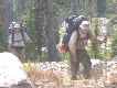
On the way back, Tuesday, we had an easy hike across the side of the
hill below North Three Links Lakes and down to upper Three Links Creek,
where we stopped to filter some more water and take a granola bar break.
We then climbed up the rock, and straight up the slope above the rock to
the bench above East Peak Lake. There, we found a wonderful grassy
little glade to camp in, near a thin little waterfall, with pikas complaining
about us interfering with them. That night we had another thunderstorm,
with lots of flash-bang and some rain.
When we awoke on Wednesday, we smelled smoke but couldn't see any -
we finally decided a lightning strike must have started a small fire on
the far side of our rocky little ridge. 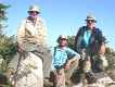 After
we packed up, we carried our packs up to the saddle and left them, to take
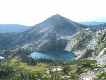
a day hike up to the top of East Peak.
After
we packed up, we carried our packs up to the saddle and left them, to take
a day hike up to the top of East Peak. 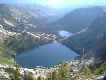 At
the top, we used the timer on my camera and John's trekking pole, which
very cleverly has a screw for cameras, to take a self portrait. I
also took some pictures of a spur of East Peak, and of Lizard Lakes, which
lie at the foot of the peak.
At
the top, we used the timer on my camera and John's trekking pole, which
very cleverly has a screw for cameras, to take a self portrait. I
also took some pictures of a spur of East Peak, and of Lizard Lakes, which
lie at the foot of the peak.
When we got back to Lone Lake, we stopped for lunch and, looking back
toward the ridge, saw smoke from one little snag fire, although it was
probably not the one we smelled that morning. 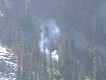 Wet
as the woods were at that point, there is little chance that the fire would
ever do anything but smolder for a while, then go out. We hiked on
over to Shasta Lake, where we managed to find a nice campsite on the far
side of the lake. Once again we had a storm, beginning almost immediately
after dinner and lasting until after dark.
Wet
as the woods were at that point, there is little chance that the fire would
ever do anything but smolder for a while, then go out. We hiked on
over to Shasta Lake, where we managed to find a nice campsite on the far
side of the lake. Once again we had a storm, beginning almost immediately
after dinner and lasting until after dark.
Thursday morning, we had an uneventful hike back down to Horse Camp, where again we picked huckleberries for dinner and breakfast and washed off in the creek. Down at the lower elevation the sky was completely clear and the weather was a dry, mellow day.
Friday morning we had a wonderful breakfast of huckleberry pancakes
covered in huckleberry syrup, packed up, and hiked out. By now we
were all in pretty good condition and the conditions were sublime - clear,
cool. We made the ten mile hike out in just over three hours, including
two rest stops; we were at the cafe in Lowell in time for a badly craved
hamburger and beer.
Last updated September 15, 2002
send comments to
cgrd@pdx.edu
.